


|
||

|

|
|

|
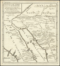
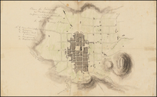
The rare first edition of Father Eusebio Francisco Kino's seminal map, which definitively ended the myth of California as an Island.
Eusebio Francisco Kino S.J. (1645-1711) was a Roman Catholic priest who became famous for his exploration of northwestern Mexico and the southwestern United States (primarily northern Sonora and southern Arizona) and for his work to Christianize the indigenous Native American population, including primarily the Sobaipuri and other Upper Piman groups. He proved that California was not an island by leading an overland expedition there from Arizona. He established twenty-four missions and visitas ("country chapels") and was known for his ability to create relationships between indigenous peoples and the religious institutions he represented.
Kino arrived in the Sonora y Sinaloa Province in 1687 to work with the Pima, where he established the first Catholic church in the Sonoran Desert. Kino traveled across Northern Mexico and to present day California and Arizona. Roads were built to connect previously inaccessible areas. His many expeditions on horseback covered over 50,000 square miles, during which he mapped an area 200 miles long and 250 miles wide. Kino was important in the economic growth of Sonora at the time, teaching the already agricultural indigenous Indian people how to grow European seed and grains, and raise foreign herd animals. Kino's initial mission herd of twenty cattle imported to Pimería Alta grew during his period to 70,000.
Kino was also a writer, authoring books on religion, astronomy and maps. He built missions extending from present day states of Mexican Sonora to Arizona. There He constructed nineteen rancherías (villages), which supplied cattle to new settlements. He was also instrumental in the return of the Jesuits to Baja California in 1697.
In addition to his pastoral activities as a missionary, Eusebio Kino also practiced other crafts and was an expert astronomer, mathematician and cartographer, who drew the first accurate maps of Pimería Alta, the Gulf of California and Baja California. His knowledge of maps and ships led him to believe that Mexican Indians could easily access California by sea, a view that was taken with skepticism by Mexico City missionaries.
Kino transmitted information back to Europe which found its way into Heinrich Scherer's maps and Nicolas De Fer's Cette Carte. The first edition of the map was printed in one of the volumes of the Jesuit reports Lettres Edifantes. It was reissued in a number of editions and languages thereafter, and is one of the landmark California maps, although a number of commercial cartographers ignored the report for 20-30 years and continued to show California as an island.
While later states of the map are available on the market, the first edition is rarely available.
![[Mexico and Central America with Baja California inset, from Generalkarte von Nord America samt den Westindischen Inseln Versasst von Herrn. Pownall . . . MDCCLXXXVIII]](https://storage.googleapis.com/raremaps/img/small/95064.jpg)
![(Oil Wells - Santa Fe Springs, Los Angeles County, California) Sante Fee Springs [sic]](https://storage.googleapis.com/raremaps/img/small/95397.jpg)