|
||

|

|
|

|
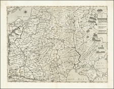
Important and extremely rare example of Anthonie Jacobsz's chart of the Baltic Sea, the first folio sized sea chart of the Baltic to appear in a commercial atlas.
Anthonie Jacobsz's chart is an enlarged and updated version of Blaeu's rare chart of the Baltic Sea and the Gulf of Finland, published in De groote Zee-spiegel. inhoudende een korte Onderswij singe in de konst der zeevaert en eene beschrijvinge der seekusten van de Oostersche, Noordsche en Westersche schipvaert enz . . . Door W. Jz. Blaeu. Niewelijcx . . . verbetert en vermeerdert. Amst. Joan Blaeu . . . , first published in 1622, with improved details along the coast, along with the addition of soundings.
Jacobsz chart of the Baltic would appear to have served as the pro-type map for Jansson's map of the same title, first published in 1650 in the sea atlas portion of Jansson's Novus Atlas, with new cartouches and the removal of the coats of arms which embellished Jacobsz map and later maps by Pieter Goos, Hendrik Doncker and others. Jacobsz's sons, Caspar and Jacob, also published a map of the same region with a similar title which follows Anthonie's chart.
Anthonie Jacobsz (listed as Anthony Jacobssen on this chart), Jacobsz founded a printing and publishing business in Amsterdam in which he specialized in the production of pilot books and sea atlases. As he died at a comparatively early age most of the numerous editions of his works appeared after his death published by his sons, Jacob and Caspar, who took the name 'Lootsman' (sea pilot) to distinguish them from another printer of the name Jacobsz.
Following Blaeu and Colom, Anthonie Jacobsz was the most important compiler of sea charts in Amsterdam in the first half of the seventeenth century. In his new ZeeSpiegel issued in 1643 he increased the number of charts normally included in these books and enlarged them to folio size, which evidently proved popular. Editions in many forms appeared until 1715 and they were copied or reprinted by Pieter Goos, Hendrick Doncker and Jan Jansson, sometimes in competition with each other but usually in cooperation with the Lootsman brothers.
The chart is of the utmost rarity. We have been unable to locate any example of the map illustrated or catalogued on line, although presumably the map appeared in Jacobsz' SeeSpiegel of 1643 or shortly thereafter.
![[ Brandenburg & Pomerania ] Tabula Electoratus Brandenburgici, Meckelenburgi et Maximae Partis Pomeraniae . . . 1630](https://storage.googleapis.com/raremaps/img/small/99232.jpg)