The item illustrated and described below is sold, but we
have another example in stock. To view the example which
is currently being offered for sale, click the
"View Details" button below.


|
||

|

|
|

|
Stock# 27357
Description
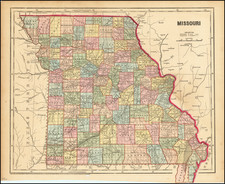
Scarce pre-Civil War map of Missouri, colored by counties and townships. Shows towns, roads, mountains, rivers, railroads, lakes, etc., which appeared in Charles Morse's General Atlas of the World.
Unlike most maps in Charles Morse's Atlas which are simply updated copies of maps from Morse & Breese's North American Atlas of 1845 , the map of Iowa is an entirely original production, replacing the Iowa and Wisconsin map which appeared in the 1845 work.
Condition Description
Minor soiling


![[ Southern Railroads ] Railroad Map of the Southern States Shewing the Southern & Southwestern Railway Connections With Philadelphia. 1862 . . . Prepared by Thomas Kimber Jr., Chairman of the Committee on Inland Transportation of the Board of Trade of Philadelphia](https://storage.googleapis.com/raremaps/img/small/103211.jpg)