


|
||

|

|
|

|
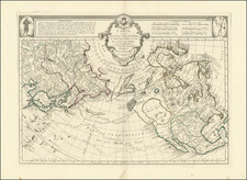
Fine full color example of Santini's edition of Joseph Nicholas De L'Isle's map of the Northern Pacific Ocean, North America and Asia, including a fine depiction of the Bay of the West.
De L'Isle's map was a cartographic landmark, representing the most important advances in the mapping of this region prior to Cook. The map reported the discoveries of numerous Russian explorers, including Tchirkow and Vitus Bering and several overland expeditions between 1731 and 1743, extending from the Northeast Passage to Alaska, and including significant new land discoveries. The routes of Frondat, Spanberg, and other Europeans explorers are also shown.
The map is a fascinating blend of modern discoveries and earlier cartographic myths, including Bay of the West and the discoveries of De La Fuca and d'Aguilar from the late 16th Centuries. The cartographic misconceptions of the region stand in stark contrast to the events unfolding across the North American continent in 1776.
The Manilla Galleon route is also shown. While the treatment of the NW Coast of America is largely conjecture and myth, the information derived from the Russians dominated regional cartography for three decades, until Cook brought significant updates.
Paolo Santini (1729-1793) was an Venetian engraver known especially for his religious prints and fine cartographic engravings. He published in Venice and may have a been a member of the clergy. In his maps, he largely adopted and adapted the work of his French counterparts, especially the brothers de Vaugondy.
![Plan du Typa ou de Macao [with] Plan De La Baye D'Awatwska…Du Kamtschatka [with] Parti Du Japon ou Nipon](https://storage.googleapis.com/raremaps/img/small/36150.jpg)
![[Alaska to San Diego and San Qunitin, British Columbia] A Chart Shewing Part of the Coast of N.W. America, with the Tracks of His Majesty's Sloop Discovery and Armed Tender Chatham . . . (First Modern Map of the West Coast of North America)](https://storage.googleapis.com/raremaps/img/small/102067.jpg)