|
||

|

|
|

|
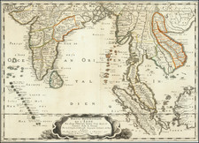
Striking map of Southern India and most of Ceylon, from Baglana, Balagata and the Kingdom of Golconda to Cape Port & Town of Gallo in Ceylon. Shows numerous Kingdoms, including, Madura, Gingi, Maissour, Canara, Visiapour, Tanjaour, Bandel, Onor, and many others. A diamond region is noted in the north and Banks of Pearls in the Coast of the Pearl Fisheries. Includes towns, rivers, roads, forests, ports, rivers, mountains and many other landmarks. A richly engraved and illustrated map from an interesting period in Indian history.
Emanuel Bowen (1694?-1767) was a British engraver and print seller. He was most well-known for his atlases and county maps. Although he died in poverty, he was widely acknowledged for his expertise and was appointed as mapmaker to both George II of England and Louis XV of France. His business was carried on by his son, Thomas Bowen. He also trained many apprentices, two of whom became prominent mapmakers, Thomas Kitchin and Thomas Jeffreys.
![[India & Central Asia] Tabula Asiae VIII](https://storage.googleapis.com/raremaps/img/small/84897.jpg)