|
||

|

|
|

|
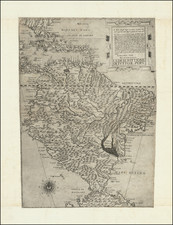
Rare plan of Blewfield's Lagoon on the east coast of Nicaragua, first published by Sayer & Bennett.
Includes an area which is identified as "English Settlers," along with ohter place names and detailed explanation of the navigational features of the Lagoon.
Abraham Blauvelt (Blewfield) was a Dutch privateer and explorer, who was responsible for mapping much of the east coast of Central America in the 1630s. Blauvelt was first recorded exploring the coasts of present day Honduras and Nicaragua in service of the Dutch West India Company. He later traveled to England in an effort to gain support to establish a colony in Nicaragua near the city where Bluefields, Nicaragua presently stands.
Around 1640 Blauvelt became a privateer serving the Swedish East India Company and in 1644 he commanded his own ship successfully raiding Spanish shipping from a base in southwest Jamaica, today known as Blewfields Bay, and selling the cargo and prizes to the Dutch colony of New Amsterdam (New York). After peace between Spain and the Netherlands was reached with the signing of the Peace of Westphalia in 1648, Blauvelt, unable to stay in New Amsterdam, instead sailed to Newport, Rhode Island in early 1649 to sell his remaining cargo. However the colonial governor seized one of Blauvelt's prizes and with his crew arguing over their shares, the local colonists, fearing that Rhode Island would acquire a reputation of trading with pirates, forced Blauvelt to leave the colony.
For the next several years Blauvelt commanded a French ship called La Garse, later living among the natives of Cape Gracias a Dios near the border of Honduras and Nicaragua, until the early 1660s when he was recruited for Christopher Myngs' raid on the Spanish colony of Campeche Bay in 1663.
Sayer & Bennett refers to the partnership of Robert Sayer (ca. 1724-1794) and John Bennett (fl. 1760-d.1787), which lasted between 1774 and 1783. Bennett had been Sayer’s apprentice. The pair specialized in American atlases, based on the work of Thomas Jefferys, who plates had been acquired by Sayer when Jefferys went bankrupt in 1766. They also began publishing navigational charts in the 1780s and quickly became the largest supplier of British charts in the trade. However, in 1783 Bennett lost control of his mental faculties and the partnership dissolved as a result. Sayer’s business was later passed to his employees, Robert Laurie and James Whittle.
![[ Mapping The Guatemala - El Salvador Border ] Mapas Que Acompañan al Informe Rendido a los Respectivos Gobiernos por la Comisión Mixta de Límites entre Guatemala y El Salvador](https://storage.googleapis.com/raremaps/img/small/105785.jpg)