


|
||

|

|
|

|
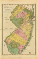
Fine example of Mathew Carey's map of New Jersey, published in Carey's General Atlas in 1818.
The map is exceptionally detailed for the period, being one of the earliest maps to show in detail the road system of New Jersey, along with early towns, rivers, mountains and other details.
Mathew Carey published the first atlas of American maps published in America in 1795, compiling a number of excellent maps from indigenous sources in the first compilation of American maps.
Carey's map is one of the earliest obtainable separately published maps of New Jersey following the American Revolution. For example, it pre-dates Gordon's map of New Jersey, the first large format map of New Jersey, the first large format map of New Jersey printed after the American Revolution, which was not published until 1828. The Gordon map, is generally considered the most important map of New Jersey published in the 19th Century: /gallery/detail/26762
An essential map for New Jersey collectors.

![[French & Indian War] Carte Des Possessions Francoises et Angloises dans le Canada et Partie de la Louisiane . . . 1756](https://storage.googleapis.com/raremaps/img/small/94026.jpg)


