|
||

|

|
|

|
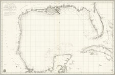
Rare early plan of the Cape Nicola Mola (Bahie du Mole and Mole Saint-Nicolas) first published by Sayer & Bennett, one of the earliest obtainable English Plans of the harbor.
Includes a detailed charting of the harbor, fort and batteries, with soundings and anchorages, and place names. While Sayer frequently credited English and Spanish sources, the anonymous reference to "a French Survey" highlights the tensions between the two 18th Century "super-powers."
Sayer & Bennett refers to the partnership of Robert Sayer (ca. 1724-1794) and John Bennett (fl. 1760-d.1787), which lasted between 1774 and 1783. Bennett had been Sayer’s apprentice. The pair specialized in American atlases, based on the work of Thomas Jefferys, who plates had been acquired by Sayer when Jefferys went bankrupt in 1766. They also began publishing navigational charts in the 1780s and quickly became the largest supplier of British charts in the trade. However, in 1783 Bennett lost control of his mental faculties and the partnership dissolved as a result. Sayer’s business was later passed to his employees, Robert Laurie and James Whittle.

![A New & Accurate Map of the Island of Cuba [on sheet with:] A New & Accurate Map of the Islands of Hispaniola and Porto Rico . . .](https://storage.googleapis.com/raremaps/img/small/77174.jpg)