This item has been sold, but you can enter your email address to be notified if another example becomes available.

Stock# 2680
Description
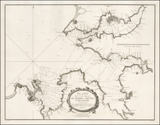
A detailed plan of the Harbor and Bay, showing the battles fought between the English and Spanish in the early 1700s, identifying fortifications, towers, battle names and locations, soundings, anchorages of the Royal Navy and other details. A scarce interesting map. The dating is pure speculation, based upon the print style and paper. Minor offsetting, else a nice impression.
![[Galicia & Asturias] Le Royaume de Galice Divise en plusieur Territoires et Les Asturies Divisees en Asturie D'Oviedo et de la Santillana Dressez Sure les Memoires de Rodrigo Mendez Silva . . . 1704](https://storage.googleapis.com/raremaps/img/small/33010mp.jpg)