|
||

|

|
|

|
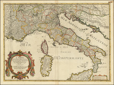
Scarce map of Northwestern Italy and neighboring parts of Switzerland and France, first published by Nicolas De Fer in 1696.
The map extends from Milan, the Genoese Coastline, Lago di Como and the Grissons in the east to the regions of Nice, Savoye, Lyon and Lake Geneva in the west, with a striking cartouche and large inset map of Les Valles de Perouse, De Pragelas, De St. Margtin, D'Angrogne et de Lucerne framed within the cartouche.
The ma was ngraved by Jacqueline Panouse, one of the few women to have engraved maps in this period. Curiously, this is the only example of a printed map which we could locate which includes the name Jacqueline Panouse, although we also located at least one manuscript map, a plan of Namur in the Bibliotheque National De France signed by Panouse. Examples of her work are clearly quite rare.
Nicolas de Fer (1646-1720) was the youngest son of Parisian print and map seller, Antoine de Fer [d.1673]. He became an official geographer to both French and Spanish kings. Nicholas de Fer was one of the most prolific and influential French geographers and cartographers of the late 17th and early 18th Century. The present example was issued by Guillaume Danet, the successor to De Fer.
Nicholas de Fer (1646-1720) was the son of a map seller, Antoine de Fer, and grew to be one of the most well-known mapmakers in France in the seventeenth century. He was apprenticed at twelve years old to Louis Spirinx, an engraver. When his father died in 1673, Nicholas helped his mother run the business until 1687, when he became the sole proprietor.
His earliest known work is a map of the Canal of Languedoc in 1669, while some of his earliest engravings are in the revised edition of Methode pour Apprendre Facilement la Geographie (1685). In 1697, he published his first world atlas. Perhaps his most famous map is his wall map of America, published in 1698, with its celebrated beaver scene (engraved by Hendrick van Loon, designed by Nicolas Guerard). After his death in 1720, the business passed to his sons-in-law, Guillaume Danet and Jacques-Francois Benard.
![[ Holy Roman Empire ] Germania del Gastaldo](https://storage.googleapis.com/raremaps/img/small/73754.jpg)
![[Untitled Map of Sicily, Sardinia and Naples]](https://storage.googleapis.com/raremaps/img/small/12524.jpg)