


|
||

|

|
|

|
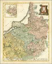
Rare map of the enivorns of Dantzick, showing the fortified walls of the City, topography and neighboring communities.
The map shows the Gulf of Dantzig, oriented with Southwest at the top, with the Vistula River entering from the left side of the map, and noting a fortification at the split in the river, along with the names and building locations of numerous smaller neighboring communities around the Gulf.
Includes decorative cartouche, surmounted by a coat of arms and elaborate, if somewhat naively engraved group of natical and miltary allegorical figures. The map is apparently quite rare, as we note only one auction record in the past 28 years, as reported by AMPR.
Nicholas de Fer (1646-1720) was the son of a map seller, Antoine de Fer, and grew to be one of the most well-known mapmakers in France in the seventeenth century. He was apprenticed at twelve years old to Louis Spirinx, an engraver. When his father died in 1673, Nicholas helped his mother run the business until 1687, when he became the sole proprietor.
His earliest known work is a map of the Canal of Languedoc in 1669, while some of his earliest engravings are in the revised edition of Methode pour Apprendre Facilement la Geographie (1685). In 1697, he published his first world atlas. Perhaps his most famous map is his wall map of America, published in 1698, with its celebrated beaver scene (engraved by Hendrick van Loon, designed by Nicolas Guerard). After his death in 1720, the business passed to his sons-in-law, Guillaume Danet and Jacques-Francois Benard.
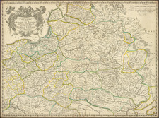
![[Poland] Mappa Geographica Poloniae, in partes suas majores, Austriae, Russie et Borussie. divisa in lucem pubicam . . . .](https://storage.googleapis.com/raremaps/img/small/60050.jpg)
![[Daugavgriva] Die Haupt Vestung Dunamunder Schanz Welche die Saxen Anno 1700. Augustusburg nandten, aber Ao. 1701. auff Discretion wider auffgeben miessen.](https://storage.googleapis.com/raremaps/img/small/60087.jpg)