


|
||

|

|
|

|
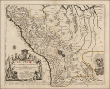
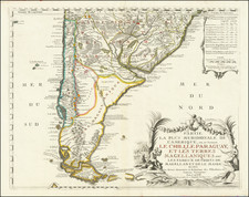
Nice example of Danet's second edition of De Fer's map of the Southern part of South America.
The striking large format map is the result of some of the most up to date cartographic information coming back to Europe from the Jesuit Missionaries who were then actively working to convert the indigenous peoples of South America to Christianity.
The map includes a significant amount of detail in the interior, along with a number of annotations addressing the discoveries of earlier explorers, including Magellan (1520), Le Maire (1616), Anthony de la Roche (1675), Brower (1643) and many others.
A nice example of this scarce map.
Nicholas de Fer (1646-1720) was the son of a map seller, Antoine de Fer, and grew to be one of the most well-known mapmakers in France in the seventeenth century. He was apprenticed at twelve years old to Louis Spirinx, an engraver. When his father died in 1673, Nicholas helped his mother run the business until 1687, when he became the sole proprietor.
His earliest known work is a map of the Canal of Languedoc in 1669, while some of his earliest engravings are in the revised edition of Methode pour Apprendre Facilement la Geographie (1685). In 1697, he published his first world atlas. Perhaps his most famous map is his wall map of America, published in 1698, with its celebrated beaver scene (engraved by Hendrick van Loon, designed by Nicolas Guerard). After his death in 1720, the business passed to his sons-in-law, Guillaume Danet and Jacques-Francois Benard.
![A Geographical Chart: or, A Scheme, Comprehending The Most Important Particulars Relative To The Geography of North and South-America. : Designed to be an Auxiliary to the Student. Carefully Compiled from the Best authorities, by Amos Bingham [Copy-Right Secured]](https://storage.googleapis.com/raremaps/img/small/41406.jpg)