


|
||

|

|
|

|
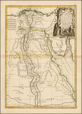
Rare Ottens edition of De Wit's decorative and highly desireable map of the region bounded by the Saudi Peninsula, Red Sea, Nile River, Cyprus, Asia Minor, the Gulf of Aden, Indian Ocean, Armenia, the Caspian Sea, Afganistan and the Indian Ocean, centered on the Persian Gulf.
Includes two attractive cartouches, ships at sea and marvelous geographical detail within the map. One of the few available Dutch maps to mention Armenia in the title of the map and one of the most detailed of the region.
The Ottens brothers, Reiner and Joshua, operated a successful printing partnership in the mid-eighteenth century (fl. 1726-1765). They began the venture in 1726, publishing maps and other prints as “R & I Ottens.” They specialized in the reprinting of others’ work, especially Guillaume De L’Isle. In 1750, Reiner died; his soon, also Reiner, took his place, but the firm began listing their works as “Joshua & Reiner Ottens.” The firm lasted until Joshua’s death in 1765. Joshua’s widow, Johanna de Lindt, sold their remaining stock of plates in 1784.
![[ Majorca, Minorca & Ibiza ] Insulae Balearides et Pytiusae](https://storage.googleapis.com/raremaps/img/small/79688.jpg)
![Constantinoplen en Egypten door Nicolaus Schmidt in enn zes Jarige Reystogt uyt Duytsland [shows Cyprus]](https://storage.googleapis.com/raremaps/img/small/57615.jpg)
![[Majorca] Ergebung der auf dem Mittellandischen Meer gelegenen Balearischn Insul Maiorica](https://storage.googleapis.com/raremaps/img/small/46077.jpg)