This item has been sold, but you can enter your email address to be notified if another example becomes available.


|
||

|

|
|

|
Stock# 25833
Description
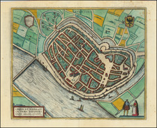
Old color example of Pieter Van Den Keere (Petrus Kaerius) map of Zeeland, from Van Den Keere's Germania Inferior id est, XVII Provinciarum ejus Novae et Exactae Tabulae Geographicae, first printed in Amsterdam in 1617. Includes an inset view of Middelburg.
This is apparently the first edition, with no text on the verso.
Van Den Keere's atlas of the Low Countries is one of the landmark regional atlases of the early 17th Century, with the maps engraved by Van Den Keere, who would go one to do significant work for John Speed and a number of other map makers of the first part of the 17th Century. The map shows the area around Antwerp in exceptional detail, showcasing Van Den Keere's engraving skills.
Condition Description
Original color. No text on verso. Moderate toning.
![[ Maastricht ] Traiectum ad Mosam](https://storage.googleapis.com/raremaps/img/small/96874.jpg)
![(France) Gallia Antiqua Ex Aevi Romani Monumentis Eruta et Serenissimi Carnutum Ducis Munificentia Publici Juris Facta [Ancient Gaul From the Roman Age, the erudite Monuments. . .]](https://storage.googleapis.com/raremaps/img/small/82019.jpg)
![[Course of the Rhine River] Corso del Reno Parte Septentrio [and] Corso del Reno Parte Meridionale . . . 1690](https://storage.googleapis.com/raremaps/img/small/73095.jpg)