|
||

|

|
|

|
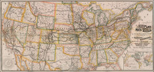
Fine example the unrecorded 1848 edition of Laurie's Fredonia, which has been substantially updated in Texas and the West.
First issued by R.H. Laurie in and edition dated 26th March, 1829, the map is one of the rarest and most sought after coast to coast maps of the United States. Rumsey refers to the map as "Ian excellent and beautiful map." As noted by Rumsey:
This map is the only one I have seen that copies almost literally three earlier maps: Lewis and Clark (1814), Long (1822), and Arrowsmith's Mexico (1820). Laurie used the term Fredonia, we may assume, to create a novelty of his map, in the same manner as his "Cabotia" map of 1814. . .. W(arren) H(eckrotte) has another edition dated 1834 improved to 1836 (with changes in California based on John Arrowsmith's Map of British North America, 1834), and the second edition of 1832. The western topography is changed to incorporate Arrowsmith's map of 1834 (British North America) and an independent Texas is shown. Editions seen of 1830, 1832, 1833, 1834, 1836, 1849. It appears that the map was updated frequently in order to keep it current.
The changes in the late editions are of significant note, as Laurie has incorporated important new information from Arrowsmith's map of British North America in 1834, especially in California and Texas. The map notes that in "Alta or Upper (formerly New) California ...it rains in winter only, excepting at Monterey." Wheat states "Long's 'Great Desert' is prominently displayed, with nearby the 'Big Horn or Long's Highest Peak,' while Escalante's route is carefully marked". This map bears a legend explaining the origin of the word "Fredonia" to designate the United States of North America, "hence Fredonian or Frede, a native of, and Fredish, of or belonging to the same territory."
In comparing this map to the map of 1836, the most notable improvement in Texas is the clear delineation of the Colorado & Red River Land Co. lands, which are drawn directly from David Burr's seminal map of Texas. A note in California has been added, noting that it only rains in the Winter, except in Monterrey, which is drawn from Coulter's paper submitted to the Royal Geographical Society in 1835. There are many other major revisions in Upper California & Oregon.
In 2005, we handled an unrecorded 1839 edition of the map. A comparison of the two shows further changes, the most notable including changes made in the course of the Canadian River. Among the other notable changes are the removal of the mythical mountain ranges in Texas, a complete redrafting of Texas's northern boundaries and reworking of the river systems in the northern part of the State.
The map is both rare and highly sought after by collectors. While Rumsey and other commentators have noted only the editions of 1830, 1832, 1833, 1834, 1836, 1849, we have previously handled an unrecorded 1839 edition and now offer this unrecorded 1848 edition. In addition, during the research for this description, we discovered an example published by R.H. Laurie dated 26th March 1829, which pre-dates the Cruchley editions of 1830 and 1832 and re-writes Rumsey's history of the map. Rumsey surmised that the map was first published by Cruchley (in the two listed editions). This earliest edition is significantly different than prior known editions, confirming the observation that it was regularly updated. The example we located, in the University of Texas Arlington Collection: http://texashistory.unt.edu/ark:/67531/metapth41353 .
The name 'Fredonia' was originated by Dr. Samuel Latham Mitchil (1764-1831), who served both as United States Senator and Representative from the State of New York. He first coined the word shortly after 1800 from the English word freedom with a Latin ending, with an idea of its meaning "place of freedom." Mitchill proposed it as a name for the United States in an article written in the Medical Repository in 1805, but it was never seriously considered (although there are now 14 cities named Fredonia in the United States).
Perhaps the most interesting Fredonia legacy is the Fredonia Rebellion, the first attempt to create a separate independent Republic in Texas. The Fredonia Rebellion (December 21, 1826 - January 31, 1827) was the first attempt by Anglo settlers in Texas to secede from Mexico. Led by empresario Haden Edwards, a group of Texas settlers declared independence from Mexican Texas and created the Republic of Fredonia near Nacogdoches, Texas. The republic encompassed land the Mexican government had granted to Edwards in 1825 and included areas that had been previously settled. Edwards's actions soon alienated these established residents, and the increasing hostilities between them and settlers recruited by Edwards led the Mexican government to revoke Edwards's contract.
In late November 1826, a group of Edwards's supporters took control of the region by arresting and removing from office several municipal officials affiliated with the established residents. A month later, the Edwards supporters declared their independence from Mexico. Although the nearby Cherokee tribe initially signed a treaty to support the new Republic, overtures from Mexican authorities and respected empresario Stephen F. Austin convinced tribal leaders to repudiate the rebellion. On January 31, 1827, a force of over 100 Mexican soldiers and 250 militiamen from Austin's colony marched into Nacogdoches to restore order.
The rebellion led Mexican President Guadalupe Victoria to increase the military presence in the area. As a result, several hostile tribes in the area halted their raids on settlements and agreed to a peace treaty. The Comanche abided by this treaty for many years. Fearing that through the rebellion the United States hoped to gain control of Texas, the Mexican government severely curtailed immigration to Texas. This new immigration law was bitterly opposed by colonists and caused increasing dissatisfaction with Mexican rule. Some historians consider the Fredonia Rebellion to be the beginning of the Texas Revolution.
Samuel Latham Mitchill (1764- 1831) was an American physician, naturalist, and politician from New York. Mitchill taught chemistry, botany, and natural history at Columbia College from 1792 until 1801. He was the founding editor of The Medical Repository, the first medical journal in the United States. At Columbia, Mitchill lectured on botany, zoology, and mineralogy, and he collected, identified, and classified many plants and animals, particularly aquatic organisms. From 1807 to 1826, he taught at the College of Physicians and Surgeons of New York and then helped organize the short-lived Rutgers Medical College of New Jersey, which he served as vice president until 1830.
Mitchell served in the New York State Assembly in 1791 and again in 1798 and was then elected as a Democratic-Republican to the United States House of Representatives, serving from 1801 until his resignation on November 22, 1804. In November 1804, Mitchill was elected a U.S. Senator from New York to fill the vacancy caused by the resignation of John Armstrong, and served from November 23, 1804, to March 3, 1809. He then served again in the House of Representatives from December 4, 1810 until March 3, 1813.
Mitchill strongly endorsed the building of the Erie Canal, sponsored by his friend and political ally DeWitt Clinton; they were both members of the short-lived New-York Institution.
Richard Holmes Laurie (1777-1858) was the son of mezzotint engraver Robert Laurie, who had taken over Robert Sayer's publishing house with James Whittle in 1794. Richard Holmes Laurie joined in a partnership with Whittle when his father retired in 1812. The name of the firm then switched from Laurie & Whittle to Whittle & Laurie. Whittle died in 1818, leaving Richard Holmes to continue publishing alone as R. H. Laurie.
When the Hydrographic Office opened in 1795, it was tasked with creating and producing all the nautical charts for the Royal Navy so as to wean the Navy off dependence on foreign charts. By the 1820s, private publishers were augmenting HO charts and competing with them, including Richard Holmes Laurie. Richard gave up publishing anything except nautical materials by 1830. He also sold charts to Trinity House, the lighthouse and maritime safety fraternity. He died in 1858.
The firm continued to print under the name R.H. Laurie even after 1858. Later, the firm was managed by Laurie’s draughtsman, Alexander George Findlay, and, later, Daniel and William Kettle.
![(Van Zandt County, Texas) [Preemption Land Grant, signed by Elisha M. Pease,1857 - Texas Land Grant on Kickapoo Creek in Nacogdoches District, Van Zandt County] Preemption. In the Name of the State of Texas](https://storage.googleapis.com/raremaps/img/small/92651.jpg)
![Die Vereinigten Staaten von Nord Amerika (Ostlicher Theil) [New York City Inset]](https://storage.googleapis.com/raremaps/img/small/62359.jpg)