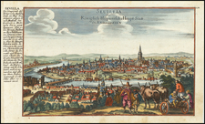
|
||

|

|
|

|
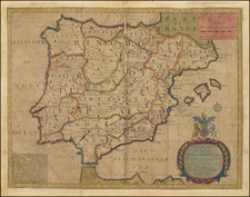
Fine early Dutch sea chart of the northeastern coast of Spain and the Balearic Islands.
The map extends from Cape S. Martin in Valencia to S. Sebastian and Cape de Palafigel in Catalonia, cetnered onteh region near Tarragona and Barcelona, with a highly detailed treatment of Majorca, Minorca and Ibiza. Includes decorative cartouche, rhumb lines and 2 compass roses.
Pieter Goos (ca. 1616-1675) was a Dutch map and chart maker, whose father, Abraham Goos (approx. 1590-1643), had already published numerous globes, land and sea maps together with Jodocus Hondius and Johannes Janssonius in Antwerp. Pieter gained recognition due to the publication of sea charts. He bought the copperplates of the famous guide book for sailors, De Lichtende Columne ofte Zeespiegel (Amsterdam 1644, 1649, 1650), from Anthonie Jacobsz. Goos published his own editions of this work in various languages, while adding his own maps. In 1666, he published his De Zee-Atlas ofte Water-Wereld, which is considered one of the best sea atlases of its time. Goos' sea charts came to dominate the Dutch market until the 1670s, when the Van Keulen family came to prominence.