The item illustrated and described below is sold, but we
have another example in stock. To view the example which
is currently being offered for sale, click the
"View Details" button below.


|
||

|

|
|

|
Stock# 2573
Description
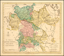
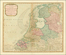
An interesting regional map, showing the Dutchys of Bremen, Holstein, Mecklenberg, Schwerin, Gustro, Magdeburg, Verden, Saxe Launberg, and others, the County of Dannenberg, a group of southern Principalities including Calenburg, Grubenhagen, Haaberstadt, Wolfenbuttel, Hildesheim, and Luneburg-Zell, and a host of Bishopricks, Archbishopricks etc. Shows towns, rivers, mountains, lakes, etc. Striking original wash colors. Robert Wilkinson was active in London as a cartographic publisher from 1785 to 1825. He produced a number of nice works, including a General Atlas and a re-issuance of Bowen & Kitchen's English Atlas, along with excellent large format separate maps.
![(Second World War - Occupation of Germany) Карта Группировки Союзных Оккупационных Войск в Германии по УКА ГСОВ в Германии [Map of the Grouping of the Allied Occupation Forces in Germany according to the UKA GSOV in Germany] | Административное Деление Германии на 1 июня 1939 Года [Administrative Division of Germany on June 1, 1939]](https://storage.googleapis.com/raremaps/img/small/72174.jpg)