|
||

|

|
|

|
Fine Example of Joined De L'Isle Maps of North and South America
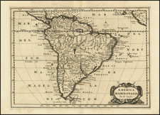
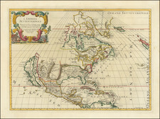
This is a rare example of De L'Isle's important maps of North and South America, joined on a single sheet of linen, as De L'Isle apparently intended. A scale and advertisement are in the upper left corner, with decorative title cartouches in the upper right and lower left corners.
De L'Isle's map of North America is a widely celebrated cartographic landmark. Because of De L'Isle's access to the information from French explorers in the New World at a time when the French dominated the explorations of the interior of the continent, De L'Isle's maps were invariably updated and innovative in their content. While his first regional maps did not appear until 1703 ( Carte du Mexique et de la Floride... and Carte du Canada ou de la Nouvelle France) and 1718 ( Carte de la Louisiane et du cours de Mississipi.... ), these maps represent De L'Isle's first work on America. They were extremely influential on other maps of the period, both for what they include and as a snapshot of the knowledge available to De L'Isle in the three years immediately prior to his issuing the regional maps.
While dated 1700, the maps were probably issued around 1707, based upon the address listed in the maps. The maps are linen backed (with the linen dating to the eighteenth century), demonstrating that the maps were clearly intended by De L'Isle to be capable of being joined as a single map. However, this is the first time we have ever encountered De L'Isle's maps mounted as a single map-a rare survival. With this joining, it is possible to appreciate the fine depiction of the various explorers' routes in the Pacific Ocean, including Sir Francis Drake, Ferdinand Magellan, Le Maire and Schouten, Olivier de Noort, and others.
The island of California
One of the most noted aspects of De L'Isle's map is that it is considered as the first map to revert to the treatment of California as a peninsula. Tooley referred to the map as "a foundation map...and the first to revert to a peninsular form of California" (Tooley, "French Mapping of the Americas" in The Mapping of America, p. 19).
However, it is more accurate to say that this map shows De L'Isle's evolving thoughts on California. Careful examination shows that the Californie and Nouveau Mexique do not meet, and the coast north of C. Mendocin is left blank. Such calculated, conservative depictions highlight De L'Isle's skill and mark this map as a crucial linchpin in the re-evaluation of the geography of California from the late-seventeenth to mid-eighteenth centuries.
From its first portrayal on a printed map by Diego Gutiérrez, in 1562, California was shown as part of North America by mapmakers, including Gerardus Mercator and Ortelius. In the 1620s, however, it began to appear as an island in several sources, including Samuel Purchas' Hakluytus Posthumus or Purchas his Pilgrimes (1625).
This was most likely the result of a reading of the travel account of Sebastian Vizcaino, who had been sent north up the shore of California in 1602. A Carmelite friar who accompanied him described the land as an island and sketched maps to that effect. Normally, this information would have been reviewed and locked in the Spanish repository, the Casa de la Contractación, but the ship carrying the map and other Vizcaino documents was captured by the Dutch. Prominent practitioners like John Speed, Jans Jansson, and Nicolas Sanson adopted the new island and the practice became commonplace. Even after Father Eusebio Kino published a map based on his travels refuting the claim (Paris, 1705), the island remained a fixture until the mid-eighteenth century.
This is not to imply that all mapmakers were blindly accepting of the convention. In 1700, roughly the same time this map was initially produced, De L'Isle discussed "whether California is an Island or a part of the continent" with J. D. Cassini; the letter was published in 1715. After reviewing all the literature available to him in Paris, De L'Isle concluded that the captured Spanish map was not trustworthy, as other Spanish maps showed California as a peninsula. He also cited more recent explorations by the Jesuits (including Kino) that disproved the island theory.
He concludes:
On my maps and globes I have taken the precaution of representing the coast as cut and interrupted in this place, as much on the side of Cape Mendocino as on the side of the Red Sea. I have left in these two places as though stepping stones during an interrupted work, and I have not believed it necessary to make up any mind about a thing which is still so uncertain; therefore I have made California neither an Island nor a part of the Continent, and I will stay with this point of view until I have seen something more positive than I have seen to date. (quoted from translation in Polk, 316)
This description precisely describes California as shown in this map, and marks this map as an important declaration of De L'Isle's broader cartographic philosophy. Later, in his map of 1722 ( Carte d'Amerique dressee pour l'usage du Roy), De L'Isle would abandon the island theory entirely. However, his contemporaries and successors, including his son-in-law, Philippie Buache, remained adherents to the island depiction. Despite such departures, this was the most influential maps in the transition from California as an island to a peninsula in the eighteenth century.
Guillaume De L'Isle's life and work
Guillaume De L'Isle (1675-1726) is probably the greatest figure in French cartography. Having learned geography from his father Claude, by the age of eight or nine he could draw maps to demonstrate ancient history. He studied mathematics and astronomy under Cassini, from whom he received a superb grounding in scientific cartography-the hallmark of his work. His first atlas was published in ca. 1700. In 1702 he was elected a member of the Academie Royale des Sciences and in 1718 he became Premier Geographe du Roi.
De L'Isle's work was important as marking a transition from the maps of the Dutch school, which were highly decorative and artistically-orientated, to a more scientific approach. He reduced the importance given to the decorative elements in maps, and emphasized the scientific base on which they were constructed. His maps of the newly explored parts of the world reflect the most up-to-date information available and did not contain fanciful detail in the absence of solid information. It can be fairly said that he was truly the father of the modern school of cartography at the commercial level.
De L'Isle also played a prominent part in the recalculation of latitude and longitude, based on the most recent celestial observations. His major contribution was in collating and incorporating this latitudinal and longitudinal information in his maps, setting a new standard of accuracy, quickly followed by many of his contemporaries. Guillaume De L'Isle's work was widely copied by other mapmakers of the period, including Chatelain, Covens & Mortier, and Albrizzi.
Ernest J. Burus, S. J., Kino and the Cartography of Northwestern New Spain, Tuscon: Arizona Pioneers’ Historical Society, 1965.
Guillaume De L’Isle, “Lettre de M. de Lisle touchant la California,” in Recueil de Voyages au Nord (Amsterdam, 1715).
John Leighly, California as an Island: An Illustrated Essay (San Francisco: Book Club of California, 1972).
Glen McLaughlin with Nancy H. Mayo, The Mapping of California as an Island: An Illustrated Checklist, Saratoga, CA: California Map Society, 1995.
Guillaume De L'Isle (1675-1726) is probably the greatest figure in French cartography. Having learned geography from his father Claude, by the age of eight or nine he could draw maps to demonstrate ancient history. He studied mathematics and astronomy under Cassini, from whom he received a superb grounding in scientific cartography—the hallmark of his work. His first atlas was published in ca. 1700. In 1702 he was elected a member of the Academie Royale des Sciences and in 1718 he became Premier Geographe du Roi.
De L'Isle's work was important as marking a transition from the maps of the Dutch school, which were highly decorative and artistically-orientated, to a more scientific approach. He reduced the importance given to the decorative elements in maps, and emphasized the scientific base on which they were constructed. His maps of the newly explored parts of the world reflect the most up-to-date information available and did not contain fanciful detail in the absence of solid information. It can be fairly said that he was truly the father of the modern school of cartography at the commercial level.
De L’Isle also played a prominent part in the recalculation of latitude and longitude, based on the most recent celestial observations. His major contribution was in collating and incorporating this latitudinal and longitudinal information in his maps, setting a new standard of accuracy, quickly followed by many of his contemporaries. Guillaume De L’Isle’s work was widely copied by other mapmakers of the period, including Chatelain, Covens & Mortier, and Albrizzi.
![The Coast of Newfoundland From Plancentia to Cape Bonavista [and] A Draught of the River Plata in South America [and] Havana, Harbour [and] the Bay of Honda](https://storage.googleapis.com/raremaps/img/small/38599.jpg)
![ПОЛИТИЧЕСКАЯ КАРТА ЮЖНОЙ АМЕРИКИ. [Political Map of South America]](https://storage.googleapis.com/raremaps/img/small/90259.jpg)