


|
||

|

|
|

|
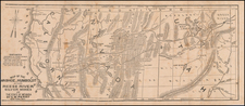
Extremely rare (unrecorded?) map of the Coeur D'Alene Silver Lead Mines, published by James McDill Porter, Mining Engineer.
The map extends from the confluence of the South Fork and the North Fork of the Coeur D'Alene River in the west to the Bitter Root Mountains and the Montana State Boundary line in the east. Along with the extensive mining detail, the map shows townships, several railroad lines, and other early details.
Along the South Fork of the Coeur D'Alene River, the towns of Wallace, Mullan, Osburn, Kellog and Kingston are shown, following the railroad line along the river.
Coeur D'Alene's mining history is one of the most fascinating, violent and enduring in the American West. The Coeur D'Alene Mining District was the richest silver district ever discovered in America and major mining operations continued for over 100 years. It is also the site of one of the biggest Superfund clean up projects in modern American history.
The history of mining in the region began with the discovery of galena (lead ore) region by Noah Kellog in September 1885, which became the Bunker Hill and Sullivan Mines. The discovery spawned a strong and sustaining industry in the area. By 1887, as a result of a pay cut by the Bunker Hill Mining Company, the miner's organized the first union in November 1887 and the ultimate formation of the Western Federation of Miners in 1888. In 1892, the miner's declared a strike, with the mine owners hiring the Pinkertons and the Thiel Detective Agency to break the strike. The resulting confrontation led to a declaration of marshall law by the Governor which lasted 4 months.
In 1899, a second confrontation occurred, when the Bunker Hill Mining Company hired the Pinkertons to spy on the miners and fired 17 union members. In response, the miners dynamited one of the Bunker Hill mining mills. At the request of the Governor, President McKinley sent the US Army to Wardner, Idaho and over 1,000 miners were held captive for an extended period of time. It was later claimed that Governor Frank Steuenberg had received a $35,000 bribe from the mine operators to intervene on their behalf.
The map is of the utmost rarity. We have located no recorded examples of this map, althoug we did find a larger map of the same title published by Porter in 1900 and revised in 1908, which is in the collection of the University of California, San Diego, the only recorded example of any of the maps, although we also note what appears to be a 1923 edition of the map as item 586 / 388.00 in the Wallace District Mining Museum list of Archived Maps and Diagrams. http://wallaceminingmuseum.org/maps.pdf
![Mexico [Texas on the Eve of Independence]](https://storage.googleapis.com/raremaps/img/small/84917.jpg)
![History of the Expedition under the Command of Captains Lewis and Clark, to the Sources of the Missouri Thence across the Rocky Mountains and Down the River Columbia to the Pacific Ocean, Performed During the Years 1804-5-6 [with map:] Map of Lewis and Clark's Track, Across the Western Portion of North America from the Mississippi to the Pacific Ocean](https://storage.googleapis.com/raremaps/img/small/92506.jpg)