|
||

|

|
|

|
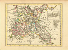
Late edition of Tobias Mayer's detailed map of Poland, updated to show the recent dismemberment of the once powerful Polish Kingdom.
Mayer's map extends from Glogau and Breslau in the West, to Braclaviensis in the South along the Dniestr Riveer, east to the Dniepr River and Mscislaw and north to include parts of Lithuania, although Curland seperates Poland from the Lithuanian Sea.
The title cartouche remains from the original map, but the decorative imperial inset in the lower left corner has been replaced by a simple scale, with a note in French at the lower left margin, noting that the color Violet identifies the regions lost by Poland in 1772.
Homann Heirs was a German publishing firm that enjoyed a major place in the European map market throughout the eighteenth century. Founded in 1702 by Johann Baptist Homann, the business passed to his son, Christoph, upon Johann’s death in 1724. Christoph died in 1730, aged only 27, and the firm was inherited by subsequent Homann heirs. This altered the name of the company, which was known as Homann Erben, or Homann heirs. The firm continued in business until 1848.
![[ Holy Roman Empire ] A Newe Mape of Germany Newly Augmented by Iohn Speed Ano Dom: 1626](https://storage.googleapis.com/raremaps/img/small/68482.jpg)