This item has been sold, but you can enter your email address to be notified if another example becomes available.


|
||

|

|
|

|
Stock# 25091
Description
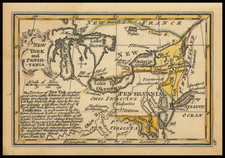
Scarce map of the Mid-Atlantic, based loosely on the Fry Jefferson map of Maryland and Virginia, from De La Porte's Atlas Moderne Portatif.
The present example is a scarce variant of the map, which includes the name "Etats Unis" off the Atlantic Coast,, whereas the earlier editions included the name Possessions Anglois. A marvelous map, published shortly after America's independence from Great Britain.
![Dominia Anglorum in America Septentrionali Specialibus Mappis Londini primum a Mollio… [4 maps--New England; Chesapeake, Georgia, Carolinas & Florida; and Nova Scotia…]](https://storage.googleapis.com/raremaps/img/small/60331.jpg)