|
||

|

|
|

|
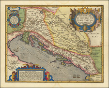
Rare map showing the area around the medieval fortress of and town of Clissa (Klis), near the city of Split in central Dalmatia, Croatia.
The map depicts the area around Klis at the time of the taking of the town by the Uskoks, with the help of the Ottoman Turks.
During the Ottoman wars in Europe, Klis Fortress was for a century an administrative centre or sanjak of the Province of Bosnia. On April 7, 1596, Split noblemen Ivan Alberti and Nikola Cindro, along with Uskoci, Polji?ani, and Kaštelani warriors, organized a liberation of Klis. Helped by part of the Turks, they succeeded in taking the town and fortress. Bey Mustafa responded by bringing more than 10,000 soldiers to the battle for the fortress. General Ivan Lenkovi? with 1,000 Uskoci came in relief of the 1,500 Klis defenders. During the battle, Ivan Lenkovi? withdrew, after he himself was wounded, and the fortress was lost to the Turks, on May 31, 1596. Turkish control of the area continued until 1645, with the outset of Cretan War. With the conclusion of the war in 1669, the town and fortress remained part of the Republic of Venice, until Napoleon took the Republic in 1797.
The map shows the castle atop a mountain, with the town below, and the ruins of the ancient Roman City of Salone (Solin), along with Molendina, Arcis Cvivsam and the course of the lower Salona River. In the bottom center, the place identified as Ysola would appear to be Vranjic.
Originally built by the ancient Illyrian tribe Dalmatae, Kliss become a royal castle that was the seat of many Croatian kings. Located on a pass that separates the Mosor and Kozjak mountains, the fortress was the site of many battles Dalmatia, with the Ottoman Empire, and was for many centuries a key crossroad.
Beginning with Prince Mislav of Littoral Croatia the middle of the 9th century, the fortress has served as the seat of many Croatia's rulers. The reign of his successor, Duke Trpimir I, the founder of the Croatian royal House of Trpimirovi?, is significant for spreading Christianity in Littoral Croatian Duchy. He largely expanded the Klis Fortress, and in Rižinice, in the valley under the fortress, he built a church and the first Benedictine monastery in Croatia. During the reign of the first Croatian king, Tomislav, Klis and Biograd na Moru were his primary castles.
In March 1242, the Tatars, under the leadership of Kadan suffered a major defeat while in pursuit of a Hungarian army led by King Béla IV. After their defeat by Croatian forces, the Mongols retreated, and Béla IV rewarded many Croatian towns and nobles with "substantial riches". During the Late Middle Ages the fortress was governed by Croatian nobility, amongst whom Paul I Šubi? of Bribir was the most significant. During his reign, the House of Šubi? controlled most of modern-day Croatia and Bosnia. Excluding the brief possession by the forces of Bosnian King, Tvrtko I, the fortress remained in Hungaro-Croatian hands for the next several hundred years, until the 16th century.
Klis Fortress is probably best known for its defense against the Ottoman invasion of Europe in the early 16th century. Croatian captain Petar Kruži? led the defense of the fortress against a Turkish invasion and siege that lasted for more than two and a half decades. During this defense, as Kruži? and his soldiers fought without allies against the Turks, the military faction of Uskoci was formed, which later became famous as an elite Croatian militant sect. Ultimately, the defenders were defeated and the fortress was occupied by the Ottomans. After more than a century under Ottoman rule, in 1669, Klis Fortress was besieged and seized by the Republic of Venice, thus moving the border between Christian and Muslim Europe further east and helping to contribute to the decline of the Ottoman Empire. The Venetians restored and enlarged the fortress, but it was taken by the Austrians after Napoleon extinguished the republic itself in 1797.
The map
![Danubii Fluminis (hic ab urbe Belgrado, per Mare Nigrum usq[ue] Constantinopolim defluentis exhibiti) pars infima](https://storage.googleapis.com/raremaps/img/small/91026.jpg)