


|
||

|

|
|

|
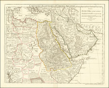
Rare Lafreri style map of Anatolia and part of Cyprus, extending from Constantnople and the Bosphorus Strait to the Euphrates River and from Cyprus to the Black Sea.
The map is a variant drawn from Gastaldi's untitled 1564 of Asia Minor, which covers a slightly larger area. The map would appear to be an entirely new plate, which includes some additions and improvements from the earlier 1564 edition and appears to also be on a larger scale than the earlier map.
The map is among the earliest obtainable maps of the region to depict modern cartographic details, rather than simply relying upon Ptolemy either entirely or as the major basis for the geographical content.
Giacomo Gastaldi was the first of a number of Italian mapmakers, mostly active in Rome and Venice, who were responsible for the production of the first widely distributed modern maps of all parts of the World. The maps were issued separately, be were also assembled both by booksellers and owners in bound composite atlases. These maps have come to be known as Lafreri maps, because in the 1570s, Antonio Lafreri of Rome produced a number of composite atlases which included a title page with his name. While there are a number of surviving examples of these Lafreri Atlases in institutions, these compilations are very rare and no two examples have identical contents.
Giacomo Gastaldi (1500-1566) is considered the foremost Italian cartographer of the sixteenth century, alongside Paolo Forlani. His skills of compilation are comparable to those of Mercator and Ortelius, yet much less is known of his life than of his two contemporaries. Gastaldi was born in Villafranca, Piedmont, but had established himself in Venice by 1539. He originally worked as an engineer, but turned to mapmaking from the 1540s onward.
It was in Venice where he made his reputation as an engraver, geographer, and cosmographer; for example, he was asked to fresco maps of Asia and Africa in the Palace of the Doge, or the Council of Ten, Venice’s governmental body. He also frequently consulted on projects for the Savi sopra la Laguna, drawing maps for this body which oversaw the regulation of fresh and salt water around Venice.
His contemporaries also recognized his skill, as he was named cosmographer to the Republic of Venice, was a member of the Accademia Veneziana, and was a major source for other geographers and mapmakers including Camocio, Bertelli, Cock, Luchini, and Ortelius. He even had his own distinct style of copper engraving that made him a pioneer in his day and makes his works iconic today.
Gastaldi enjoyed an especially productive relationship with Giovanni Battista Ramusio, Secretary of the Venetian Senate, who used Gastaldi's maps for his famous travel account collection, Navigationi et Viaggi. Gastaldi also tutored Ramusio's son in cosmography.
![[ Gonzaga Family History Dating Back to Constantinople ] Paleologi Imperatores Constantinopolitani, et Marchiones Montisferrati...](https://storage.googleapis.com/raremaps/img/small/99753.jpg)
![Il Disegno Della Terza Parte Dell' Asia [Gastaldi's Wall Map of SE Asia with extra panels!]](https://storage.googleapis.com/raremaps/img/small/30554hbp.jpg)