This item has been sold, but you can enter your email address to be notified if another example becomes available.


|
||

|

|
|

|
Stock# 24483
Description
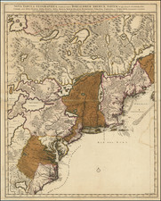
Santini's map of Colonial America, the region from the Chesapeake to Florida, west to Natchitoches and the Arkansas River, north along the Mississippi River to the Fort de Chartes area and then east along the Ohio River toward Maryland, which is named, and including all of the Del-Mar-Va peninsula.
While the map is based upon D'Anville's highly important 4 sheet map of North America. The map shows Indian Tribes, mountains, rivers, towns, forts and a host of other eraly information.
This is the first edition of the map, which is dated 1776.

![[Right sheet only of: A New Chart of America Florida to New York with the Principal Harbours on a Large Scale, Drawn from the latest Authorities, by Robt Blachford. 1807.]](https://storage.googleapis.com/raremaps/img/small/55819.jpg)