|
||

|

|
|

|
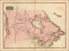
Rare Du Val map of Canada, the Great Lakes and Northeast, based upon Sanson's earlier maps of the region.
The present example is the second edition, with Indian Tribal names added in the West (unlike the first state), but pre-dating the addition of Mer Du Canada above Mer Du Nord and the addition of Manhate, B. Chesapeak, Boston, I. de Sable, Passage du Nord north of Newfoundland, and 3 Rivieres.
Excellent example of the open ended Great Lakes to the West. Clearly shows a Northwest Passage through Hudson's Bay. Extends south to Virginia and names Florida.
Pierre Duval (1618-1683) was a French geographer, cartographer, and publisher who worked in Abbeville and Paris during the seventeenth century. He was born in the former city, in northeast France, before moving to Paris. Duval was the nephew of the famous cartographer Nicolas Sanson, from whom he learned the mapmaker's art and skills. Both men worked at the royal court, having followed the royal request for artists to relocate to Paris. In addition to numerous maps and atlases, Du Val's opus also includes geography texts. He held the title of geographe ordinaire du roi from 1650 and died in 1683, when his wife and daughters took over his business.
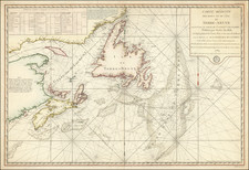
![[ The Finest Colonial New England Sea Chart of the 18th Century ] The Coast of New England](https://storage.googleapis.com/raremaps/img/small/63672.jpg)