|
||

|

|
|

|
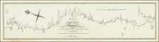
Important early map of the Indian Lands, west of the Mississippi River, setting forh the location of the major western forts on the American Frontier.
The map is based upon surveys conducted by Washington Hood, shortly before his death. Shows area to the west of the Mississippi, from Fort Snelling to the Gulf of Mexico.
The map was one of 2 maps, which was part of a report of the Secretary of War, with plans for the defence and protection of the western frontiers of the United States, and statements of the number of Indians and warriers on those frontiers. [p. 777-786] Many tribes that will be moved to Indian Territory are shown. Published in Report from the Secretary of War ... in Relation to the Protection of the Western Frontier … January 3, 1838. Senate Document 65, p. 2, Serial 314. Reference \
The area covered extends from the Mississippi River to the Rockies. U. S. Army forts are shown; most are 150 or more miles west of the Mississippi. Fort Snelling is the northern-most; Ft. Jackson, the southern-most. Indian tribal lands are identified. A few roads are shown.
![Partie De L'Amerique Septent? Qui comprend La Nouvelle France ou Le Canada . . . [Large Great Lakes Inset]](https://storage.googleapis.com/raremaps/img/small/48752.jpg)
![[Mormon Trail] Utah And the Overland Routes to it, from the Missouri River: Published with](https://storage.googleapis.com/raremaps/img/small/66366.jpg)
![[ Hungarian Traveler In the California and the West with a Comanche and Wichita to Hungarian vocabulary ] Levelei Éjszakamerikából -- Tizenkét eredeti rajzok után készült kő- és egynéhány fametszettel. Közli Prépost István (Letters from North America)](https://storage.googleapis.com/raremaps/img/small/98502.jpg)