This item has been sold, but you can enter your email address to be notified if another example becomes available.


|
||

|

|
|

|
Stock# 23985
Description
Rare large format map of the Comstock mining region, with a large birdseye view across the top, showing the town of Virginia City in the foreground and Mount Davidson in the distance.
The map shows name, location, and size of all Comstock Mines. Includes railroad lines, flumes, rivers, roads, mine shafts, etc. The town plan for Virginia City appears, as does the extent of construction on the Sutro Tunnel. An important early Comstock mining map, which rarely appears on the market.
Condition Description
Flattened and backed with thin layer of paper to support old fold weakness, with minor loss. Upper right corner replaced with facsimile.
![[Report and] Map of an Exploring Expedition to The Rocky Mountains in the Years 1842 and to Oregon & North California in the Years 1843-44 By Brevet Capt. J. C. Fremont of the Corps of Topographical Engineers . . .](https://storage.googleapis.com/raremaps/img/small/88488.jpg)
![[San Joaquin Valley] Valley of Kah Wee Ya River (Four Creeks)](https://storage.googleapis.com/raremaps/img/small/90289.jpg)
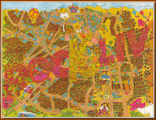
![[Berkeley] This Is The Map of Berkeley Town Its Streets Go Winding Up & Down An Oak-Covered Campus It Wears For A Crown With People & Places of Renown](https://storage.googleapis.com/raremaps/img/small/97201.jpg)