


|
||

|

|
|

|
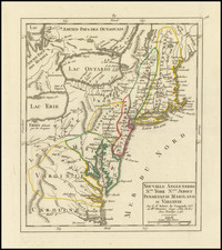
Rare second edition of this early map of the region from New York City to Cape Henry, centered on the Cheaspeake and Delaware, from Abraham Wolfgang's L'Amerique Angloise, ou Description des Isles et Terres dur Roi Angleterre, dans L'Amerique, published in Amsterdam in 1688.
The Blome-Wolfgang map includes a key showing 29 place names (mostly county name) in the first edition and 30 place names in the second edition of Wolfgang's map. Burden notes:
this map is not derived from any clear source. An unusually slim New Jersey is depcited and the border between Maryland and Pennsylvania is placed too far north, just south of Philadelphia. The Delaware peninsula is leaning eastwards slightly and is broader at its neck than accepted at the time.
A fine example of this rare map.
![[ Carolinas & Georgia ] Carte De La Caroline Et Georgie . . .](https://storage.googleapis.com/raremaps/img/small/99744.jpg)
![[ Southern Railroads ] Railroad Map of the Southern States Shewing the Southern & Southwestern Railway Connections With Philadelphia. 1862 . . . Prepared by Thomas Kimber Jr., Chairman of the Committee on Inland Transportation of the Board of Trade of Philadelphia](https://storage.googleapis.com/raremaps/img/small/103211.jpg)
![(Coast of Florida, Georgia and the Carolinas] [To The Members Of The Nautical Institution And Ship-Masters' Society Of The City Of New York, This Chart, Extending From Lat. 40°15 N., Long. 72°15 W., to Lat. 22°35 N., Long. 80°25 W., Is Respectfully Dedicated / By Their Obedient Servant Edmund M. Blunt]](https://storage.googleapis.com/raremaps/img/small/77294.jpg)