![The State of North Carolina from the best Authorities [manuscript annotations] By John Reid](https://storage.googleapis.com/raremaps/img/small/101026.jpg)


|
||

|

|
|

|
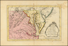
One of the earliest obtainable seperately issued maps of the State of North Carolina.
John Reid's map of North Carolina, based upon Samuel Lewis' map of 1795, which had been issued in William Guthrie's New System of Modern Geography, published by Matthew Carey. Reid's map provides a large format and highly detailed map of the state, showing towns, roads, rivers, mountains, swamps, counties, meeting houses, and substantial other detail.
Williams & Johnson note that the first state of the Lewis/Carey map does not delineate counties (although they are named), which has been followed by Reid in this map. The area around present day Forsyth County is squared off with a dotted line, showing the boundaries of the Moravian Community of Wachovia. The coastline of the Outer Banks shows only a slight eastward slant. The Reid map includes the names of the various counties, although no boundaries are shown. Many roads are shown.
Following Mathew Carey’s publication of the American Atlas in 1795, the second large format atlas published in America was produced by John Reid of New York in 1796. The project began as an atlas to accompany William Winterbotham’s An Historical, Geographical, Commercial and Philosophical View of the United States, but was also sold separately under the title The American Atlas.
Reid’s atlas included 20 maps. In addition, John Russell’s plan of Washington, D.C. is also bound into some copies of the Atlas. Reid’s atlas was a collaborative work, with 9 of the maps engraved by Benjamin Tanner, 5 by David Martin, two by D. Anderson and one each by John Scoles and John Roberts. Two of the maps do not include engraving credits. Each of the engravers was probably working in New York (including Tanner, who had not yet relocated to Philadelphia). According to the various entries for the maps in Wheat & Brun, the cartographic content of the maps is drawn largely from Carey’s first atlas of 1795.


![[ Revolutionary War Map Showing Rochambeau's March from Boston to the Chesapeake ]](https://storage.googleapis.com/raremaps/img/small/103560.jpg)