|
||

|

|
|

|
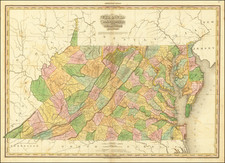
The Bishop Madison 6-sheet A Map of Virginia formed from actual surveys and the latest as well as most accurate observations . . . is one of the rarest and most important of all maps of Virginia published in the 19th Century.
Engraved by Frederick Bossler and based upon the work of Wlliam Prentis and Willaim Davis derived from local surveyors, it was the most authoritative map of Virignia until Hermann Boye's map of 1827. The map is popularly referred to as the Bishop Madison map, owing to the dedication to Madison, Prentice and Davis, in the title.
The sheet offered here covers Lee, Russell, Tazewell, and Washington County and parts of Gray and County, along with part of Kentucky. It was the single most important and accurate map of its time and is cornerstone map for Virginia collectors. The complete map very rarely appears on the market.
Bishop James Madison was the first cousin of President James Madison. He served as Presdient of William & Marry College for 35 years. As President, he and the board of Trustees for the college were responsible until 1779 for selecting Virginia's Surveyor General. Madison served on the commission that defined the Virginia-Pennsylvania Boundary in 1779. As a result of these activities, he became aware of the need for an updated map of the Commonwealth, which would improve upon the Fry & Jefferson map.
Madison began work on the map in 1802. Among other things, he sought to provide the first detrailed treatment of the roads in Virginia and to delineate the new developments in the westerrn part of the state and to make general improvements to the accurate mapping of the Commonwealth. He was assisted at times by his first cousin, the future President Madison, and by Thomas Jefferson. The Western and Middle Regions are based upon the earliest surveys of the counties in these regions.
Completed in 1805, the manuscript was presented to the legislatrue, which elected not to fund the publication of the map. As a result, the map was published by subscription and as a result is now very rare on the market.
The inset map of Ohio which appears on the Northeast sheet, is one of the earliest maps of Ohio based upon an actual survey and is not listed in Smith's The Mapping of Ohio. The map was extensively revised for the second edition of the map.

![[ Florida Native Americans -- Idol Worship ] Idolum Kiwasa XXI](https://storage.googleapis.com/raremaps/img/small/98017.jpg)