|
||

|

|
|

|
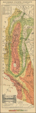
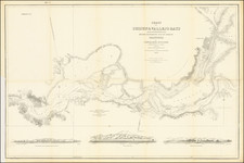
Rare separately issued map of California and Nevada, noted by Carl Wheat and others as one of the most important and up to date maps of the two states of the period.
Frey's map is a highly important map of the period, meriting a mult-page description in Wheat's Mapping of the Transmississippi West. As noted by David Rumsey:
Williamson's proposed route through the Owyhee to the Idaho mines is shown, as well as much current detail in central Nevada and all of California. The influence of Williamson's 1866 "Map of Parts of California, Nevada, Oregon and Idaho Territory" (both the published and the ms version) is obvious. A wheel shows the "Difference of time between S. Francisco and other important Cities."
This may be Louis Nell's first commercial map, before his extensive work for the Wheeler Survey in the 1870's and his Colorado maps of the 1880's. The railroad map shows the Union Pacific completed to Cheyenne and the Central Pacific to the Nevada border. This is both a beautiful map and an excellent depiction of California and Nevada just before the completion of the railroad. Wheat mentions that the towns of the Humboldt valley are sprinkled with names that disappear in a few years with the coming of the railroad. Full color by county.
The treatment of Nevada is of considerable note, as one of the earliest maps to provide a detailed treatment of Nevada, on the eve of its earliest mining booms.
As noted by David Rumsey, this is quite possibly the first printed map by Louis Nell, whose maps of Colorado would become the most authorititative maps of Colorado for more than 30 years.
The map is of the utmost rarity, with only a few copies appearing on the market in the past 100 years (Eberstadt 1938, Midland 1947, Norris Sale 1947 (which was purchased by the Holmes Book Company and sold to Streeter), Streeter 1969 and the Rumsey copy. OCLC locates only 1 example (Bancroft). Yale also holds a copy. Not listed in Library of Congress on line catalogue.
Full Title: Topographical Railroad & County Map of the States of California and Nevada Compiled from the latest explorations and other official information by L. Nell, N.Y. 1868. Published by Frey & Nell, 79 Nassau St. New York. General Agents for California A. Roman & Co....San Francisco. Ferd. Mayer & Co. Lithographers 96 Fulton St. N.Y. Entered...1868 by Frey & Nell...Southern District of New York. .
![[Limited Edition of 33] The Sculpture & Art of Jo Mora](https://storage.googleapis.com/raremaps/img/small/94900.jpg)