


|
||

|

|
|

|
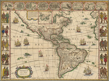
Rare early example of Blaeu's map of America, with no text on the verso.
Blaeu's map of America is one of the most sought after maps of America from the Golden Age of Dutch Cartography, blending contemporary georgaphical knowledge and a rich decorative image. Blaeu's maps set the standard for the quality of the engraving, paper and color, as well as a fine depiction of contemporary geographical knowledge.
This map illustrates excellent detail throughout, including a classical rendition of the West Coast of America (which did not follow the California as an Island myth) and dozens of place names along the East Coast. Nine decorative views of important American Cities and Harbors across the top and 10 fine miniatures of Native Americans of various regions along the side panels. The map is also embellished with eight sailing ships, four sea monsters and vignettes in the interior of the continent showing Indian life. Goss states "this magnificent map sums up the general European view of the western hemisphere in the early seventeenth century…"
As noted by Burden, State 3 of the map, first published in 1621, appears both with and without text on the verso. The examples without text are typically pre-1630, according to Burden. The present example was folded into a small folio volume and was quite likely separately issued and used by an owner or early bookseller to illustrate a book which would otherwise have not included this map. The print impression is dark and strong, reflecting an early use of the plate, which more commonly appears in the fourth state, first issued in 1642 and can be distinguished by the much more elaborate markings in the sea.
These early examples of Blaeu's map of America are quite rare on the market. Early examples without text panels periodically appear on the market, such as the one which illustrated Van Meteren's
Warhafftige Beschreibung Aller Denckwurdigsten Geschichten .... However, the early versions with the panels and without text on the verso are very rare on the market.
Willem Janszoon Blaeu (1571-1638) was a prominent Dutch geographer and publisher. Born the son of a herring merchant, Blaeu chose not fish but mathematics and astronomy for his focus. He studied with the famous Danish astronomer Tycho Brahe, with whom he honed his instrument and globe making skills. Blaeu set up shop in Amsterdam, where he sold instruments and globes, published maps, and edited the works of intellectuals like Descartes and Hugo Grotius. In 1635, he released his atlas, Theatrum Orbis Terrarum, sive, Atlas novus.
Willem died in 1638. He had two sons, Cornelis (1610-1648) and Joan (1596-1673). Joan trained as a lawyer, but joined his father’s business rather than practice. After his father’s death, the brothers took over their father’s shop and Joan took on his work as hydrographer to the Dutch East India Company. Later in life, Joan would modify and greatly expand his father’s Atlas novus, eventually releasing his masterpiece, the Atlas maior, between 1662 and 1672.
![Totius Americae Septentrionalis et Meridionalis Novissima Representatio . . . [California as an Island - First State!]](https://storage.googleapis.com/raremaps/img/small/104253.jpg)