|
||

|

|
|

|
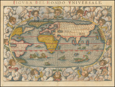
Scarce double hemisphere map of the World by Petrus Plancius, engraved by Baptista Van Deutecum in Amsterdam in 1590.
As noted by Shirley, this world map is "one of [Plancius's] earliest productions," and is based upon Rumold Mercator's world map of 1587, but with corrections in South America and the inclusion of the Solomon Islands, derived from Ortelius. In addition to these changes, Plancius adds information derived from the latest Portugese information regarding the west coast of America and the west coast of Asia. The depiction of Japan as one of three large islands is also unusual.
The depiction of the Arctic is consistent withe Mercator's world map, as is the massive unknown southern continent, which includes references to Beach and other Marco Polo era names.
While at first glance, the map looks similar to Mercator's map of 1587, the two are easily distinguished from one another, including the Van Deutecum signature at the bottom of the map, the decorative flourish in the top right corner of the title and the variation in the titles (Mercator's map is enttled " Orbis Terrare Compendiosa Descriptio . . ."). The map is also considerably rarer than Mercator's map. Shirley notes that "most of the maps prepared by Plancius are uncommon, if not rare, as they are not reprinted in standard atlas form."
Plancius's map first appeared in 1590, with Plancius' name in the title. Later editions appear in 1612 and 1621. The present example is Shirley's State 3, with Plancius's name replaced by "D.R.M. Mathes." It is uknown whether Mathes is a person or an abbreviation for Mathemetician. Jan Van Doetecum engraved a variant edition of the map, published by Paulus Merula in 1605.
The map rarely appears in good condition and frequently appears with significant loss of image, making this unrestored example even more rare.
Petrus Plancius (1552-1622) was born Pieter Platevoet in Dranouter in West Flanders. He trained as a clergyman in Germany and England, but he was an expert not only in theology but in geography, cosmography, and navigation. After fleeing prosecution by the Inquisition in Brussels, Plancius settled in Amsterdam where he first began his forays into navigation and charting. As Amsterdam was a hub for trade, Plancius was able to access Portuguese charts, the most advanced in the world at that time. Plancius used these charts to become an expert in the sailing routes to India, knowledge that gained him opportunity. Plancius was one of the founders of the VOC, for whom he worked as their geographer. He also served on a Government Committee to review the equipment needed for exploratory expeditions.
![Western Hemisphere [and] Eastern Hemisphere](https://storage.googleapis.com/raremaps/img/small/90387.jpg)
![[Medieval World Map] Das ist die mapa mudi und alle Land un Kungkreich wie sie ligend in der ganze Welt](https://storage.googleapis.com/raremaps/img/small/102356.jpg)
![Ленин – вождь международного пролетариата [Lenin – Leader of the International Proletariat]](https://storage.googleapis.com/raremaps/img/small/93242.jpg)