
![L'Amerique Septentrionale divisee en ses principaux Etats…1762 [Sea of the West] By Jean Janvier](https://storage.googleapis.com/raremaps/img/small/98745.jpg)


|
||

|

|
|

|
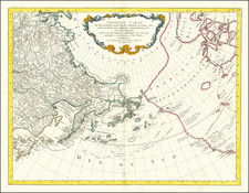
Nice example of Janvier's map of North America, one of the signature mid-18th Century maps for North American and Northwestern map collectors.
The Bay of the West appears in its usual configuration, which is present in at least 3 states of this map, as are the configurations of the Straits of Juan De Fuca and Martin Aguilar. The map is known in a number of transitional states, of which this state is perhaps the most interesting. The Tchirickow/De L'Isle coastline reminiscent of the Alaskan Archipelago above the words Mer Du Sud has been removed.
The mythical river system crossing Canada is still in evidence. Lac Michinipi ou des Assinibouels is shown. The sources of the Missouri and Mississippi Rivers are shown, albeit speculatively so. A few early French forts still appear in the Transappalachian West.
Sea of the West first appeared on the maps of Jean Baptiste Nolin circa 1700, which were drawn from manuscript maps by Guillaume De L'Isle, although De L'Isle himself never published a printed map with this configuration. The myth reached the height of its popularity in the second half of the 18th Century, following the reports of French cartographers Guillaume de l'Isle and Phillipe Buache. Under Buache and De l'Isle's influence, the Sea of the West, Mer de L'Ouest, or Baye de l'Ouest reached its fullest expression and commonly appeared on maps from the 1740s until the results of Captain James Cook's explorations along the Northwest Coast of America became well known.
![[ Trans-Atlantic Cable ] Amerique Septentrionale avec l'indication des Principaux Courants marins d'Amerique en Europe](https://storage.googleapis.com/raremaps/img/small/98084.jpg)
![[ Cook's Discoveries in Russian America ] Chart of the NW Coast of America and the NE Coast of Asia explored in the Years 1778 & 1779 . . .](https://storage.googleapis.com/raremaps/img/small/68831.jpg)
