|
||

|

|
|

|
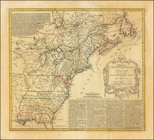
Rare wall map of the United States by David Burr, almost certainly intended to be the successor to Abraham Bradley's postal map of the United States.
David Burr is one of the most famous, yet ironically little understood mapmakers during the first part of the 19th Century. His two most famous works, the Postal Atlas of the United States (1839) and Atlas of the State of New York (first published in 1829) are among the most import cartographic works of their respective genres, yet relatively little is known about Burr.
An extensive search of the market has turned up copies of the map at the Library of Congress and 3 other examples, plus an example in private hands.
David H. Burr originally worked under Simeon DeWitt, New York State's Surveyor General at the beginning of the 19th century. Burr had a brief career as a lawyer and an aide-de-camp for New York Governor De Witt Clinton before being appointed to his first position in charge of a team surveying a portion of the state for a proposed road in 1825. He then succeeded in getting approval from the state legislature to compile an atlas that included maps of each county as well as a separate map of the entire state. These were dated 1829, but not actually published until early 1830. Burr's atlas has the distinction of being the second atlas published in the 19th century of one of the individual states in the U.S., preceded only by Mill's Atlas of South Carolina (1825).
In the 1830s, Burr produced an important early map of Texas and was in the process of publishing is New Universal Atlas in the late 1830s, when he was apparently offered work as a mapmaker for the United States House of Representatives. He produced several maps for the House, before beginning work for the Post Office on a series of maps which would become his most imporant work. Work on the maps was completed by the end of 1839, at which time Burr contracted with John Arrowmsith in London to print the maps. During this time period, he clearly fell out of favor with the House, and by 1841 his position with the government had been terminated. I this same time period, he petitioned the US Government for a tariff exemption on the import of his Postal Atlas and separate maps, which he apparently wished to distribute privately. The tarriff exemption was turned down, leaving Burr with a $10,800 unpaid printing bill and essentially bankrupt.
It was during this same time that Burr apparently produced the present map. While there is no record of its being made under the auspices of the United States government, the dating of the map (January 1842) and its size and detail, clearly suggest that it was compiled during the same time period and from the same information as the postal atlas. In fact, a close examination shows that many of the details on this map are identical too, and/or derived directly from the same source.
It is reasonable to surmise that the map was intended by Burr to be a successor to Abraham Bradley's general postal map of the United States, which was more than 10 years out-dated by the time Burr began his project. The general map which accompanied Burr's postal atlas is basically a key map, with no real postal or other detail, and clearly not incorporating the details of the rest of the maps in the postal atlas. Moreover, as noted at the time of Burr's tarrif hearings, the Government has ordered very few separate copies of the general map of the US in the postal atlas, with only one on hand at the time of the hearing, providing additional circumstantial evidence that Burr intended a larger format general map of the US of similar detail to the general maps of the postal atlas.
Of equal interest, Burr's title of Topographer of the United States Post Office and Geographer to the House of Representatives, may in fact have been self-appointed titles. In the proceedings reflecting his censure and termination, Burr was classified as a clerk and his superiors derided for having allowed temporary clerical positions to have grown far beyond their intended scope, perhaps because of the political weight carried by Burr's older brother, who seems to have initially recruited Burr to service.
During his time with the Post Office, Burr produced his Postal Atlas of the United States. This "atlas" is one of the great rarities of American 19th century cartography, with complete sets being almost impossible to find. John Arrowsmith engraved the plates in London, an unusual collaboration at this late a date between an American cartographer and a London engraver.
Burr also served as surveyor to the states of Florida and Louisiana, then returned to Washington and became geographer to the U.S. Senate. In the 1850s, President Franklin Pierce named him the surveyor general of Utah Territory, where as the top ranking federal official in the territory, he was "heavily involved with the legal and jurisdictional disputes between Mormon leaders and the U.S. government" (Ristow).
David H. Burr studied law, passing the New York Bar Exam, and then surveying under Simeon DeWitt in New York. His first atlas was an atlas of New York State (1829), the second state atlas to be issued in the US (after Mills’ Atlas of South Carolina in 1826). In the 1830s, he served as the official topographer for the US Post Office, producing a series of rare and highly sought-after large-format state maps. He also created a map of the country’s postal routes, which features roads, canals, and railroads. Burr traveled to London to work with John Arrowsmith; together, they produced the American Atlas in 1839.
Upon his return to the States, Burr was appointed as a draftsman for the House of Representatives, where he worked until ca. 1841. He later worked for the Louisiana Survey and the Florida Survey. By 1850, he was back in Washington D. C., working on the census. In 1852, the Senate named Burr as the draftsman to compile maps from the Federal Surveys. In 1853, Burr traveled to San Francisco, perhaps as part of his work for the Senate. He was then named as the Surveyor General of Utah in 1855. However, he was unpopular there and returned to Washington D. C. by 1870. Burr is widely regarded as one of the most important names in the nineteenth-century American history of cartography.
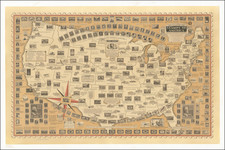
![[Unusual Italian Immigrant Communities shown!] America Settentrionale, Centrale e Meridionale -- Carta Dimostrativa Delle Ambasciate, Legazioni, Consolati (Con Le Risettive Circoscrizioni Territoriali), Camere Di Commercio, Agenzie Commerciali, Stazion Enotecniche, Uffici Postali, Ospedali, Scuole Governative e Sussidiate All'Estero](https://storage.googleapis.com/raremaps/img/small/86098.jpg)
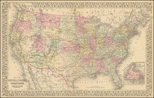
![[ Atlas of The United States ] Karte von Amerika](https://storage.googleapis.com/raremaps/img/small/84353mp2.jpg)