|
||

|

|
|

|
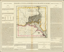
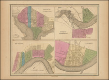
Nice example of the Eastern part of Tardieu's wall map of the United States, based on Arrowsmith's 4-sheet map. The southeast sheet also includes a fine large format plan of Washington DC, copied from the Ellicott Plan.
Tardieu's map of the United States is one of the rarest and most interesting large format maps of the period. The map is based upon the true first state of Arrowsmith's 4-sheet map of the United States. The map is completely re-engraved by Tardieu and reflects the finer engraving skills of this Paris engraver. In addition to the decorative cartouche present in Arrowsmith's map, Tardieu has added a plan of Washingtion DC, based upon Ellicott's plan.
Arrowsmith's map of the US is a landmark of American Cartography prior to Lewis & Clark and probably the most famous and widely disseminated large format map of the recently independent United States published after the American Revolution. The inclusion of the Ellicott plan of Washington DC on Tardieu's map makes the map also one of the earliest large format examples of the Ellicott Plan published outside of the United States.
This example is also of great interest for the advertising that appears in the lower margin of the lower sheet. The margin note includes printed information noting that the map was then being offered for sale by Charles Picquet in London, Treuttel et Wurtz in Strasbourg and Paris and J Goujon in Paris. This annotation reflects a very early appearance of the Paris map seller and publisher J. Goujon, prior to his association with the Andriveau family, an association with would last for almost the entire 19th Century and produce some of the most interesting large format maps published in France, under the business name of Andriveau-Goujon.
12/12/2013
- Kasarah
Pierre Antoine Tardieu (1784-1869), also known to sign his works as PF Tardieu, was a prolific French map engraver and geographer. The Tardieu family, based in Paris, was well known for their talent in engraving, cartography, and illustration. Pierre Antoine’s father, Antoine Francois Tardieu, was an established cartographer who published numerous atlases. His son is said to have collaborated with him for many years before establishing his own independent career.
Pierre Antoine Tardieu’s most famous work includes engravings of the islands of La Palma and Tenerife, for which in 1818 he was awarded a bronze medal by King Louis-Phillipe for the beauty and accuracy of his mapping. Other famous work includes his mapping of Louisiana and Mexico, engravings of Irish counties, maps of Russia and Asia, and his highly celebrated illustrations of all the provinces of France. He was also the first mapmaker to engrave on steel.
Tardieu was a popular map engraver in his lifetime, enjoying the patronage of the likes of Alexander von Humboldt and respect among his peers. In 1837, he was appointed the title Chevalier de la Légion d’honneur. As was written in his obituary in the Bulletin of the Geographical Society of France, he was renowned for his combination of technical talent and scholarly research skills and praised for furthering his family’s well-respected name in the scientific arts.