This item has been sold, but you can enter your email address to be notified if another example becomes available.


|
||

|

|
|

|
Stock# 2295
Description
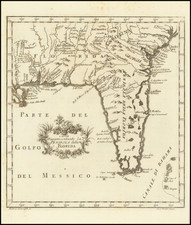
Extraoridinarily detailed Revolutionary War ear map of the Gulf Coast from the Appalachia River in Florida to the Red River in Louisiana, centered on the course of the lower Mississippi, Mobile Bay and Pensacola Bay. The map extends inland along the Mississippi to approximately the Mississippi-Louisiana border. The map includes rhumb lines, hundreds of soundings, anchorages, and notes of early settlements. There are also nots concerning Crevecoeur and a Spanish landing in 1718 and 1719. The map has been cleaned and backed with archival paper to support some old tears. However, the map remains a scarce early detailed map of the region, perhaps the most detailed of the era.

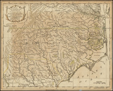
![[Jefferson's Notes on the State of Virginia] Observations sur la Virginie [with the map:] A Map of the country between Albemarle Sound, and Lake Erie, comprehending the whole of Virginia, Maryland, Delaware, and Pensylvania, with parts of several other of the United States of America. Engraved for the Notes on Virginia.](https://storage.googleapis.com/raremaps/img/small/51828.jpg)