


|
||

|

|
|

|
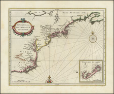
Reference Sellers and Van Ee, Map 1367, and illustrated on their page 293. Striking and highly detailed chart of Delaware Bay and the mouth of the River, extending from Cape May in the south to Bombay Hook in the north.
Des Barres chart of Delware Bay was unquestionably the most detailed chart of the Bay produced during the colonial period. This is the second state, extending from Bombay Hook in the North to Cape Henlopen in the South. In describing the map, Sellers and Van Ee note " Few harbors in America were as carefully charted as Delaware Bay during the colonial period. British naval surveyors were at work in Delaware Bay on the eve of the American Revolution."
This fine chart appeared in the Atlantic Neptune by Captain Joseph Frederick Wallet des Barres. The Atlantic Neptune was remarkable, multi-volume set of sea charts and coastal views prepared from surveys by Samuel Holland, Thomas Hurd, and Charles Blaskowitz. The maps were prepared under the supervision of Des Barres and employed as many as twenty engravers and assistants. The Atlantic Neptune is one of the finest large scale sea atlases of the U.S. and Canadian Atlantic coast line ever produced. The maps in the atlas were produced over six year period (1775-81), and are well known for their accurate portrayal of various sounds, bays, bars, and harbors as well as navigational hazards. This atlas was used extensively by the Royal Navy during the American Revolution.
Joseph Frederick Wallet Des Barres (1721-1824) was born in either Paris or Basel, Switzerland, to a Hugueont family. He studied under the great mathematician Daniel Bernoulli at the University of Basel before immigrating to Britain, where he trained at the Royal Military College, Woolwich.
Upon the outbreak of hostilities with France in 1756, he joined the British Royal American Regiment as a military engineer. He came to the attention of General James Wolfe, who was impressed with his charting ability. During this period, he also worked with the legendary future explorer, James Cook, on a monumental chart of the St. Lawrence River.
Des Barres is best known for the Atlantic Neptune, was a remarkable, multi-volume set of sea charts and coastal views prepared from recent surveys, some of which were overseen by Des Barres in Nova Scotia after the Seven Years’ War. The maps, charts, and views were prepared under the supervision of Des Barres and employed as many as twenty engravers and assistants. They were produced over the course of a decade, from 1774 to 1784, in time to be used by the Royal Navy in the American Revolution.
After the Revolution, Loyalists were resettled throughout Canada. As part of this process, a new colony was created by separating Cape Breton from Nova Scotia. Des Barres, who already owned extensive lands in the Maritimes, served as lieutenant governor of Cape Breton Island from 1784 to 1787. He later served as governor of Prince Edward Island from 1804-1812.
Des Barres lived an exceptionally long life, even by today's standards, finally dying at age 102. Des Barres' funeral was held at St. George's Round Church in 1824 and he is buried in Halifax.

![[ Virginia / Maryland / Chesapeake Region ] Pas Kaart van de Zee Kusten van Virginia Tusschen C. Henry ent Hooge Land van Renslaars Hoek. . .](https://storage.googleapis.com/raremaps/img/small/47255.jpg)
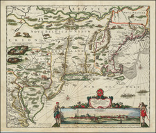
![[Carolinas, Virginia, the Chesapeake, Pennsylvania, New York]](https://storage.googleapis.com/raremaps/img/small/71479.jpg)
![Dominia Anglorum in America Septentrionali Specialibus Mappis Londini primum a Mollio… [4 maps--New England; Chesapeake, Georgia, Carolinas & Florida; and Nova Scotia…]](https://storage.googleapis.com/raremaps/img/small/60331.jpg)