


|
||

|

|
|

|
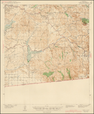
Rare highly detailed large format map of California & Nevada, published by the A.L Bancroft & Co. of San Francisco in 1882, which includes an apparently unique birdseve view of Virginia City, Nevada.
A.L Bancroft and the predecessor Hubert Howes Bancroft firm, began publishing maps of California, Nevada and the greater western US States and Territories in the early 1860s. As noted by Rumsey, the history of Bancroft's mapping of the west probably begins about 1863, with the production of Bancroft's Map of the Padiic States, a 4 sheet production (62 x 48 inches)., in 4 sheets. In describing his own 1867 editiion of the map, Rumsey notes that the map of the Pacific States was:
. . . the "mother" map for Bancroft's several issues of the pocket map versions of the northern and southern halves of this map, as well as for many later issues of this map. It is wonderfully detailed, full of endless information on the western states, information that is found in few other maps of the same period. . . .
Following production of the 1863 map of the Pacific States, Bancroft and Charles Knight issued the complete map, along with separate 1 and 2 sheet portions of the map under various titles for a number of years, althought the predominant issuance dates for the 4 sheet map and smaller segments seem to be 1864 to 1868 and again beween 1873 and 1878.
In 1882, A.L. Bancroft & Co. apparently made the decision to make a completely new version of the 4 sheet version of the map. While issued in almost exactly the same size as the original map (61 x 48 inches), it includes 2 major changes. First, this revised map covers only California and Nevada (rather covering most of the region south of Canada and west of the Rocky Mountains as had the Pacific State map). Second, the focal point of the map would become transportaion and explosive mining and mineral businesses of the west, which had come to dominate the economy of Nevada in the period. To illustrate the new map, Bancroft included a large birdseye view of Virginia City, Nevada, then one of the most famous and important mining boom towns in the West.
Unlike the earlier versions of the map, which were probably intended for travellers making there way west or navigating between relatively distant points, the new map was intended for field use. The new map offered by the publisher in a dissected format, mounted on a durable linen and sold laid into a loose set of boards, for easy use in the field. As a result, while the early Bancroft maps were vest pocket guides which survive in relative abundance, only 3 recorded examples of the Bancroft's "New Map" have survived. OCLC notes only copies held by The Amon Carter Museum (Ft. Worth Texas), Massachusetts Historical Society and Bancroft Library (UC Berkeley). Of the 3 recorded examples, 2 are identified as being dissected in 4 sheets and neither of these seems to include the covers which were issued with the present example. Accordingly, it would appear that only the Bancroft Library copy conforms to the preseent example (ie. complete with the original boards).
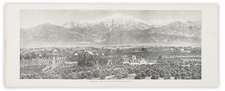
The most unique unique feature Bancroft's "New Map" is the Birdseye View entitled Virginia City, Nevada in the lower left part of the map. The view appears to be an entirely unqiue projection, not a reduction or variant of one of the other views of the city then in existence. Comparisons of th view to separate views by GT Brown, Glover, Shober & Co. and Augustus Koch are very different in both perspective and theme. These other views of Virginia City were done from a different orientation and capture an image of a small hillside mining town, not a commercial boom town. The present view includes a large mill and other signs of real commerce. The most obious example of this difference is the large image of the California Pan Mill (bottom right), which had been built in 1875 by the Bonzana Firm. While not captured in any lithographic views we were able to locate, later photographs of Virginia City, such as those by Carelton Watkins in the Nevada State Historic Preservation Office, show this mill as one of the major commercial enterprises of Virignia City.
Virginia City is one of the oldest established communities in Nevada and one of the most famous boomtowns in the Old West. It virtually appeared overnight as a result of the Comstock Lode silver strike of 1859. During its peak, Virginia City had a population of nearly 30,000 residents. During the 20 years following the Comstock success "about $400 million was taken out of the ground". The town's final demise was put in motion when the Comstock Lode ended in 1898. Virginia City is also famous for being the birthplace of "Mark Twain," where a young Samuel Clemens, as a reporter for the Territorial Enterprise in February 1863, first used his now famous pen name. Local records also show that he was mugged one night in November 1863, shortly before relocating. The perpetrators claimed the act a practical joke, but Twain's writings in Roughing It. (1872) suggest he did not see the same humor in event.

![La Parte Occidentale Dell'Antico, E Nuovo Messico Con Florida E La Bassa Luigiana…. 1798 [California & The Southwest!]](https://storage.googleapis.com/raremaps/img/small/95816.jpg)
![[California Wine Advertising Graphic] Italian Swiss Colony Producers of Choicest California Wines Asti Colony Tipo](https://storage.googleapis.com/raremaps/img/small/83467.jpg)
![Wines from California | Wine Land of America [Vineyard scene]](https://storage.googleapis.com/raremaps/img/small/93655.jpg)