![[ Southeast Asia ] Tabula Nova Indiae orientalis & meridionalis By Lorenz Fries](https://storage.googleapis.com/raremaps/img/small/100399.jpg)


|
||

|

|
|

|
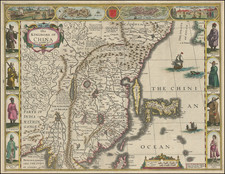
Nice full color example of the first printed map to focus on the Southeast Asian islands and the only map to focus on this area in the first half of the 16th Century.
Fries map was a significant milestone in the mapping of Southeast Asia. The map shows Lake Chiang Mai, which feeds one of the region's principal rivers. The cartography is based upon Waldseemuller's 1507 cordiform map, which derived its treatment from Martellus. The map abandons the Ptolmaeic model in several respects, most notably the closed Indian Sea.
Much of the map's nomenclature is derived from Marco Polo's adventures. Java Major is mapped solely from annectodal reports. Peutam (Binan) is recorded in the 13th Century treatise of Ibn Sa'id. Java Minor is correctly placed below Peutam. Fries treatment of Sumatra is also much more accurate than the maps of Waldseemuller, et al. Ferlec is show opposite Bintam, based upon Marco Polo's account that it was located 100 miles to the south. Basma is also shown on the northern coast.
In the Mapping of Southeast Asia, Tom Suarez spends several pages illustrating and descibing the minute detail in the map and reconciling it against the works of early travellers and prior maps, calling this map a landmark in the cartography of Southeast Asia.
Lorenz (Laurent) Fries (ca. 1485-1532) was born in Mulhouse, Alsace. He studied medicine, apparently spending time at the universities of Pavia, Piacenza, Montpellier and Vienna. After completing his education, Fries worked as a physician in several places before settling in Strasbourg in about 1519. While in Strasbourg, Fries met the Strasbourg printer and publisher Johann Grüninger, an associate of the St. Dié group of scholars formed by, among others, Walter Lud, Matthias Ringmann and Martin Waldseemüller.
From 1520 to 1525, Fries worked with Grüninger as a cartographic editor, exploiting the corpus of material that Waldseemüller had created. Fries' first venture into mapmaking was in 1520, when he executed a reduction of Martin Waldseemüller's wall map of the world, first published in 1507. While it would appear that Fries was the editor of the map, credit is actually given in the title to Peter Apian. The map, Tipus Orbis Universalis Iuxta Ptolomei Cosmographi Traditionem Et Americ Vespucii Aliorque Lustrationes A Petro Apiano Leysnico Elucubrat. An.o Dni MDXX, was issued in Caius Julius Solinus' Enarrationes, edited by Camers, and published in Vienna in 1520.
Fries’ next project was a new edition of the Geographia of Claudius Ptolemy, which was published by Johann Grüninger in 1522. Fries evidently edited the maps, in most cases simply producing a reduction of the equivalent map from Waldseemüller's 1513 edition of the Geographie Opus Novissima, printed by Johann Schott. Fries also prepared three new maps for the Geographia, of Southeast Asia and the East Indies, China, and the world, but the geography of these derives from Waldseemüller's world map of 1507.
The 1522 edition of Fries' work is very rare, suggesting that the work was not commercially successful. In 1525, an improved edition was issued, with a re-edit of the text by Willibald Pirkheimer, from the notes of Regiomontanus (Johannes Müller von Königsberg).
After Grüninger's death in ca. 1531, the business was continued by his son Christoph, who seems to have sold the materials for the Ptolemy to two Lyon publishers, the brothers Melchior and Gaspar Trechsel, who published a joint edition in 1535, before Gaspar Trechsel published an edition in his own right in 1541.
![[ India -- With Epitaph Lieutenant Edward Holmes ] To Mark Wood Esq. M.P. Colonel of the Army in India Late Chief Engineer and Surveyor General, Bengal. This Map of India Compiled from various Interesting and Valuable Materials Is Inscribed in grateful Testimonial of his Liberal Communications By his obedient and most humble Servant A. Arrowsmith . . . 1804](https://storage.googleapis.com/raremaps/img/small/99889.jpg)