
This item has been sold, but you can enter your email address to be notified if another example becomes available.


|
||

|

|
|

|
Stock# 22515
Description
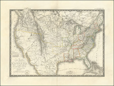
Rare early map of a portion of the Midwest and regions to the East, from Lake Michigan to Kentucky and Virginia to Maine.
Includes a curiously misshaped Ohio and a massive Indiana, which extends from the Ohio River to Lake Huron and Lake Michigan, incorporating all of what would become Michigan (except the Upper Peninsula) and Illinois. The detail in Virginia is also noteworthy for the period. This is the largest treatment of Indiana we have ever seen. Issued in the year after Indiana's Statehood, with no mention of the Territory of Illinois or the Territory of Michigan.
Only the 2nd time we have offered the map between 1993 and 2009.
![[Eurpean and American Air Routes] TWA Trans World Airline U.S.A. • Europe • Africa • Asia Air Routes](https://storage.googleapis.com/raremaps/img/small/89027.jpg)
![[ Southern Railroads ] Railroad Map of the Southern States Shewing the Southern & Southwestern Railway Connections With Philadelphia. 1862 . . . Prepared by Thomas Kimber Jr., Chairman of the Committee on Inland Transportation of the Board of Trade of Philadelphia](https://storage.googleapis.com/raremaps/img/small/103211.jpg)
![A Map of Lewis and Clark's Track Across the Western Portion of North America, from the Mississippi to the Pacific Ocean. By Order of the Executive of the United States in 1804, 5 & 6. . . . [Complete with 3 volumes of Text: Travels to the Source of the Missouri River and Across the American Continent to the Pacific Ocean. Performed by Order of the Government of the United States, in the Years 1804, 1805, and 1806].](https://storage.googleapis.com/raremaps/img/small/81775.jpg)