


|
||

|

|
|

|
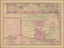
Rare early map of Indian Territory from the 1879 edition of Cram's Railroad Atlas.
Cram's map of Indian Territory was first published in 1875 and was available as a separately issued map and in the the 1875 edition of Cram's Atlas. The 1879 edition is printed from the same plate, with a number of notable changes, including the addition of an alpha-numeric location system on the top, bottom and sides of the map, a significant innovation which was just then being introduced on printed maps.
Within the map itself, the most noteworthy changes are the additins of Cherokee Town, Stone Wall and Erin Sp. in the Chickasaw Nation, So. Canadian, McAllister, Rogers Station, Stringtown, and Luklala in the Chocktaw Nation, Lightening Creek, Claremore, Chocteau, Locust Creek, and Tahlequah in the Cherokee Reservation, Muscogee, and Webber Falls in the Creek Nation, changes in the projected railroads through the Territory.
The map is very rare on the market. This is the first example of the 1879 edition we have offered in more than 15 years and there are no examples listed in AMPR in the past 25 years. We also handled one example of the 1875 edition.
George F. Cram (1842-1928), or George Franklin Cram, was an American mapmaker and businessman. During the Civil War, Cram served under General William Tecumseh Sherman and participated in his March to the Sea. His letters of that time are now important sources for historians of the Civil War. In 1867, Cram and his uncle, Rufus Blanchard, began the company known by their names in Evanston, Illinois.
Two years later, Cram became sole proprietor and the company was henceforth known as George F. Cram Co. Specializing in atlases, Cram was one of the first American companies to publish a world atlas. One of their most famous products was the Unrivaled Atlas of the World, in print from the 1880s to the 1950s.
Cram died in 1928, seven years after he had merged the business with that of a customer, E.A. Peterson. The new company still bore Cram’s name. Four years later, the Cram Company began to make globes, a branch of the business that would continue until 2012, when the company ceased to operate. For the final several decades of the company’s existence it was controlled by the Douthit family, who sold it just before the company was shuttered.