|
||

|

|
|

|
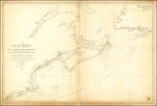
Detailed map of the southern part of Newfoundland and the Grand Banks, showing the prime fishing region of the North Atlantic.
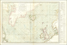
One of the earliest detailed sea charts of the region. Arent Roggeveen created the first maritime atlas dedicated to the Americas, beginning in 1675. Roggeveen began his career as a mathematician, surveyor and navigator. He began tutoring Dutch pilots of the East India and West India Companies and in 1675 proposed a voyage to the Pacific, which never came to fruition. His time as a tutor provided him access to a number of the secret charts, including manuscript charts of Dutch and Spanish origin. Over the course of 20 years, he compiled maps which culminated in the production of his Het Brandened Veen (The Burning Fen).
The work was intended to be a 4th and 5th Volume to Pieter Goos's Zeespiegel. Rogeeven's work would become the most detailed charting of the coast of North America and the Caribbean to date. Unlike Goos' charts, these maps are extremely rare. First issued in 1675, a later edition bearing Jacob Robijn's imprint was issued in 1680, after Rogeveen's death.
Arent Roggeveen was a land surveyor, mathematician, poet and teacher of navigation. Born in Delfshaven, he later moved to Middelburg where both the Dutch East and West India Companies were based. He was employed by both companies as a teacher in the art of navigation. He also helped maintain their collections of hydrographic manuscripts and charts, including Spanish portulanos of the West Indies. In the mid-1660s, Roggeveen compiled a series of large scale charts of the North American coastline, West Indies and later, West Africa. His Het Brandende Veen or The Burning Fen represented a landmark in the coastal charting of North America, with a number of regions mapped in a larger scale than in any previously printed work. Roggeveen arranged for Pieter Goos, one of the leading engravers and publishers of maritime books in Amsterdam to publish the collection. The completed work was the first Dutch pilot that was focused on select areas of the American coastline. Previously, all printed maps and charts that dealt with this coastline were on a much larger scale.
Roggeveen died in 1679. Goos' widow sold the plates to Jacob Robijn, who reissued the maps with his name added to the title, but otherwise unchanged, in 1680. Both examples of the map are extremely rare. The atlases were undoubtedly published in limited quantities. Working sea charts and pilots from the 17th Century are inherently rare due to the nature of their use aboard ships. The vast majority of them were either destroyed by use or destroyed intentionally when new updated versions were obtained.
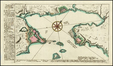
![The Coast of Newfoundland From Plancentia to Cape Bonavista [and] A Draught of the River Plata in South America [and] Havana, Harbour [and] the Bay of Honda](https://storage.googleapis.com/raremaps/img/small/38599.jpg)