|
||

|

|
|

|
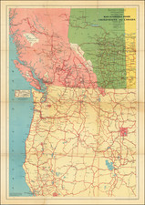
Exceedingly rare map Map of Lewis & Clark County, compiled and drawn by John C. Van Hook.
The map is elegantly embellished with a large photograph of the County Courthouse in Helena and an elaborate testimonial from the 3 county commissioners (signatures shown), attesting to the authenticity of the map.
The map is divided by townships and shows towns, roads, railroad lines, forest reserves, Indian lands. The county was established in 1865 as Edgerton County, and was renamed Lewis & Clark County in 1867.
John C. Van Hook served as the State Forester of Montana. He and John H. Hibbard also prepared a map of the state of Montana in 1902, aptly named The Hibbard and Van Hook State Map of Montana. Compiled from the latest official records, John H. Hibbard, John C. Van Hook. Helena, 1902.

![Carte Des Etats-Unis Du Mexique 1836 [Republic of Texas]](https://storage.googleapis.com/raremaps/img/small/103417.jpg)
![[ Idaho Below Montana ] Verein-Staaten am Stillen Ocean… [inset of San Francisco Bay] [Unusual Idaho & California configurations]](https://storage.googleapis.com/raremaps/img/small/99297.jpg)