


|
||

|

|
|

|
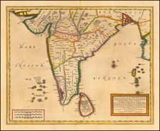
An attractive map of the region bounded by Northern India, Pakistan, Afganistan and Bangladesh and extending inland up the Ganges and Indus Rivers to Tartary and the Himalayas, including Katmandu, Kabul and other legendary cities along the great trading route. Extends south to include a large portion of India, including Narsinga, Orixa Decan, etc. Elephants shown roaming the Ganges and Camels east of Kabul. Decorative cartouches and sailing ships.
Henricus Hondius (1597-1651) was a Dutch engraver and mapmaker, a member of a prominent cartographic family. His father, Jodocus Hondius, was also an engraver and geographer. While working with his father, Henricus was instrumental in the expansion and republishing of Mercator’s atlas, first published in 1595 and republished by Hondius in 1606.
Upon his father’s death in 1612, Henricus and his brother, Jodocus the Younger, took over the business. He set up his own shop in 1621, where he continued to release new editions of the Mercator atlas. Later, he partnered with his brother-in-law, Jan Janssonius, in continuing to expand and publish Mercator’s atlas, which would become known as the Mercator-Hondius-Janssonius atlas. Born and based in Amsterdam, he died there in 1651.

![Turkey in Asia [Including Cyprus]](https://storage.googleapis.com/raremaps/img/small/98704.jpg)