|
||

|

|
|

|
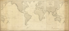
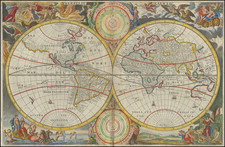
Detailed map of the World on Mercator's projection, originally engraved for Wyld's General Atlas.
The present example has been updated from the Wyld edition, most notably with a reference to the points reached by the Blossom. This is a reference to Beechey's expedition of 1825-28.
Frederick William Beechey (1796-1856) was an English naval officer and geographer, who entered the Royal Navy in 1806, and saw active service during the wars with France and America. In 1818 he served under John Franklin in David Buchan's Arctic expedition and later published a narrative of the expedition. In 1819, Beechey accompanied Lieutenant W. E. Parry on the first of the Hecla's 3 voyages in search of the Northwest Passage. In 1821, Beechey surveyed the Mediterranean coast of Africa under William Henry Smyth.
In 1825, Beechey took command of the HMS Blossom on a voyage to explore the Bering Strait. The Blossom passed the Strait and penetrated as far as 71°23'31" N., and 156°21'30" W., reaching a point about 400 feet west of that reached by Franklin's simultaneous expedition from the Mackenzie River. In 1831, his Narrative of a Voyage to the Pacific and Berings Strait to Co-operate with the Polar Expeditions, 1825-1828 was published in London.
In 1835-36, Beechey surveyed the coast of South America. From 1837 to 1847, he surveyed the Irish coast. In 1850, he was appointed to preside over the Marine Department of the Board of Trade. In 1854, he was made rear-admiral, and in the following year was elected president of the Royal Geographical Society.
![[ Wright- Molyneux Map ] [ New mapp of the world according to Mr. Edward Wright commonly called Mercator's projection ]](https://storage.googleapis.com/raremaps/img/small/99967.jpg)