|
||

|

|
|

|
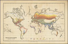
Rare 18th Century facscimile and Latinized interpretation of Al-Idrisi's important 12th Century map of the World.
Al Idridi's map of the world is one of the earliest surviving world maps to provide an accurate contemporary depiction of the known world. With information to England, Russia and Finmark, the map depicts the best available geographical information known to inhabitants of the Mediterranean region during the period. Curiously, the present map is depicted with north at the top, unlike the original, which shows South at the top. The map is also translated from the original Arabic annotations, with place names, rivers, mountains and oceans titled in Latin. The map maker almost certainly had access to both an earlier manuscript or printed facsimile of the map and a translation of the text.
Mohmmed Al-Idrisis (1110-1166) wrote one of the most important early travel accounts of Europe and produced one of the earliest extant world maps. Al Idrisi was born in Cetua and travelled to Spain, Portugal, France and England at a very early age. He visited Anatolia when 16. After troubled times in his native Andalusia, Al-Idrisi moved to Sicily, which had recently been conquered by the Normans.
Al-Idrisi compiled a written account of the knowledge of Africa, the Indian Ocean and the Far East gathered by Islamic merchants and explorers recorded on Islamic maps, and information provided by the Normans, to create the most accurate map of the world in pre-modern times. The map illustrates Al Idrisi's Kitab nuzhat al-mushtaq ( Opus Geographicum or A Diversion for the Man Longing to Travel to Far-Off Places).
Al-Idrisi would later prepare the so-called Tabula Rogeriana map in 1154 for the Norman King Roger II of Sicily. Al-Idrisis worked for 18 years in the court of King Roger II, preparing commentaries and illustrations of the map. The map, with legends written in Arabic, shows the Eurasian continent in its entirety, but only shows the northern part of the African continent but lacks details of the Horn of Africa and Southeast Asia.
The only reference to the map which we could locate is in Peter Whitfield, The Image of the World, p.28/29. We are aware of only one other example of the map appearing at auction in the past 25 years and no examples in dealer catalogues.
![Western Hemisphere [and] Eastern Hemisphere](https://storage.googleapis.com/raremaps/img/small/77831.jpg)
![[ Tycho Brahe's Geocentric Model of the Earth ] Scenographia Compagis Mundanae Brahea.](https://storage.googleapis.com/raremaps/img/small/98590.jpg)
![World [Rand, McNally & Company's Indexed Atlas of the World]](https://storage.googleapis.com/raremaps/img/small/100314.jpg)