|
||

|

|
|

|
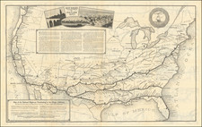
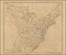
A nice example of Weiland's rare map of the United States.
According to Arkway (in descxribing the 1824 edition of the map):
The Library of Congress owns the only recorded example of the 1821 edition; neither edition is in OCLC or RLN. According to Wheat, Weiland's map "follows Lewis and Clark's map, but with this difference, that the Fraser [River] is missing while the entire Columbia is present. The result is that the United States is shown from the 42nd parallel extending north to take the entire Columbia watershed and from there to the sea. Despite the omission of the Fraser, the geography in the little-known west seems more up-to-date than the geography in the east. The shapes of the Great Lakes, for example, are unique or archaic. Lake Michigan is too long and narrow, and Weiland's Lake Superior is unlike any delineation in Mapping the Great Lakes Region (1977): the lake looks like a pair of lungs separated by several islands. Issued originally the same year that Missouri was admitted as a state in 1821, this publication of the Weimar Geographischen Instituts was one of the first European maps to recognize the controversial new state over which the Missouri Compromise was fiercely debated.
Indian tribes are identified throughout the western territories and estimates of their populations are provided. This is an early map to locate Champ d'Asile, a colony of Bonapartist refugees founded in Texas on the Trinity River in 1818. Spanish troops were dispatched from San Antonio to expel the colony, which was abandoned within the year. Champ d'Asile was included on the first edition of the map in 1821. Maps that locate the colony are uncommon. . . .
Carl Ferdinand Weiland (1782-1847) published two atlases, Atlas von Amerika (1824-28) and Algemeiner Hand-Atlas (1828-48). Weiland's large map presents the boundary of Texas in its then ambiguous state. Texas stands out on the map, having an ambitiously exaggerated Panhandle. Texas is designated Provinz Texas and is shown as part of Provinz Cohahuila, San Luis Potosi, Neu Santander, and even the eastern edge of New Mexico (Santa Fe is shown practically on the border). The northern boundary west of the Rocky Mountains extends north to take in the whole of the Columbia watershed.
One of the earliest coast to coast maps of the US published in Europe.