


|
||

|

|
|

|
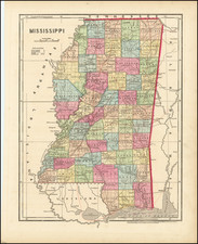
Rare revised full color edition of Morse's cerographic map of Mississippi, divided by parishes and townships. Shows towns, roads, mountains, rivers, railroads, lakes, etc.
This is the second edition of the map, originally issued in Morse & Breese's North American Atlas was a landmark in American Cartography, being the first atlas to employ the cerographic printing process, which would revolutionize the map trade. The Morse family and this process are the subject of David Woodward's The All American Map. The maps were first printed in a series of inserts which appeared in the New York Post, and then later as a separate atlas.
An essential map for American Map collectors, illustrating an important change in the history of printed maps and the only truly American cartographic publishing innovation.
![[Florida Panhandle to Yucatan] Pas-Kaart Van de Golff van Mexico . . .](https://storage.googleapis.com/raremaps/img/small/93130.jpg)