|
||

|

|
|

|
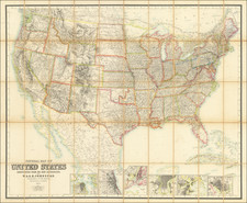
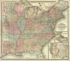
Scarce large format map of th United States, by David Burr, one of the most important American Map makers of the first part of the 19th Century.
The map depicts the mail collection districts in the US, using red lines to indicate district boundaries and yellow lines to distinguish states and territories. Arizona and New Mexico are shown as one territory, Nebraska includes the present states of the Dakotas and Wyoming, West Virginia has not separated from Virginia, Utah spans from California to Kansas, and Washington and Oregon extend to the Continental Divide. Indian Territory is unnamed. Burr was Geographer and Draftsman to the Senate from 1855 to 1859.
David H. Burr studied law, passing the New York Bar Exam, and then surveying under Simeon DeWitt in New York. His first atlas was an atlas of New York State (1829), the second state atlas to be issued in the US (after Mills’ Atlas of South Carolina in 1826). In the 1830s, he served as the official topographer for the US Post Office, producing a series of rare and highly sought-after large-format state maps. He also created a map of the country’s postal routes, which features roads, canals, and railroads. Burr traveled to London to work with John Arrowsmith; together, they produced the American Atlas in 1839.
Upon his return to the States, Burr was appointed as a draftsman for the House of Representatives, where he worked until ca. 1841. He later worked for the Louisiana Survey and the Florida Survey. By 1850, he was back in Washington D. C., working on the census. In 1852, the Senate named Burr as the draftsman to compile maps from the Federal Surveys. In 1853, Burr traveled to San Francisco, perhaps as part of his work for the Senate. He was then named as the Surveyor General of Utah in 1855. However, he was unpopular there and returned to Washington D. C. by 1870. Burr is widely regarded as one of the most important names in the nineteenth-century American history of cartography.